| |


Tour the Old Erie Canal
Prints, Photographs and Postcards
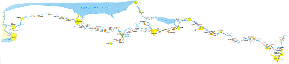
This section of The Erie Canal Site takes you on a pictorial trip along the Erie Canal from
Buffalo in the west to Albany in the east. Although some of the images are unique to this
section, most of the images you will see duplicate those found in both the
Images of the Erie Canal and Traces of
the Old Erie Canal sections, but are arranged in geographical order from west to east. On
each of the four pages, you may click on a city, feature or area name on the map and you will be
sent to pictures of the Erie Canal in or near that city or area, or of that feature. To begin the tour,
either click on an area of the map above, or on one of the links below.
Warning! The maps on each page are large and may be slow to load in
dial-up situations. In addition, the maps are meant to be viewed at a 1024 x 768 resolution or
better. At low-resolution settings much west-to-east scrolling may be necessary. In these
situations, it may be better to view the images from the Images of the
Erie Canal and Traces of the Old Erie Canal sections.
Tour the Erie Canal:
|
|