
Home | Canal System | Historical Documents | 175th Anniversary | Images | Maps | Tour | Traces | Locks | Boats | Books and Videos | Music | Links

 Building of the first aqueduct to carry the Erie Canal over the Genesee River at Rochester was
started in the fall of 1821, with completion in September 1823. Built of Red Medina sandstone
with a coping of Onondaga Limestone, it was 802 feet long and 17 feet wide and had 11 arches.
This first aqueduct had a problem with leakage, and construction began in 1836 on a new
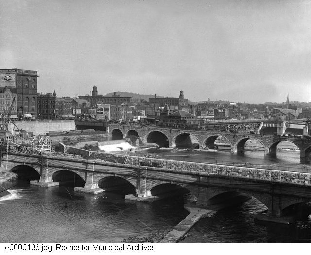
aqueduct a short distance to the south. This second aqueduct, made of Onondaga Limestone,
was placed in service in 1842. It crosses the river on seven arches of fifty two feet span each,
resting on six piers and two abutments, each ten feet thick. The arched portion extends 444 feet,
and the whole length including wing-walls is 800 feet. The original trunk was 65 feet, with an
overall width of 70 feet. This is the structure that exists today as the base of the Broad Street
Bridge.
Building of the first aqueduct to carry the Erie Canal over the Genesee River at Rochester was
started in the fall of 1821, with completion in September 1823. Built of Red Medina sandstone
with a coping of Onondaga Limestone, it was 802 feet long and 17 feet wide and had 11 arches.
This first aqueduct had a problem with leakage, and construction began in 1836 on a new
aqueduct a short distance to the south. This second aqueduct, made of Onondaga Limestone,
was placed in service in 1842. It crosses the river on seven arches of fifty two feet span each,
resting on six piers and two abutments, each ten feet thick. The arched portion extends 444 feet,
and the whole length including wing-walls is 800 feet. The original trunk was 65 feet, with an
overall width of 70 feet. This is the structure that exists today as the base of the Broad Street
Bridge.
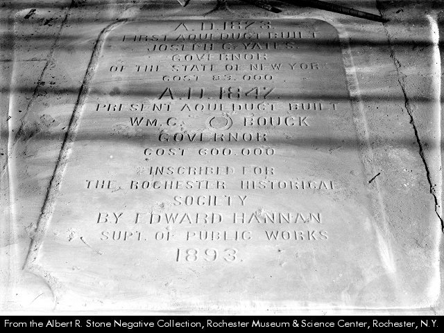
The image to the right is the Historical tablet for the Rochester Aqueduct (From: Albert R. Stone Negative Collection, Rochester Museum & Science Center). The tablet was affixed to the Erie Canal Aqueduct in 1893 to memorialize the construction history of the aqueduct. The text reads, "A. D. 1823. First aqueduct built. Joseph C. Yates, Governor of the State of New York. Cost 83,000. A. D. 1842. Present aqueduct built. Wm. C. Bouck, Governor. Cost 600,000. Inscribed for the Rochester Historical Society by Edward Hannan, Supt. of Public Works, 1893".
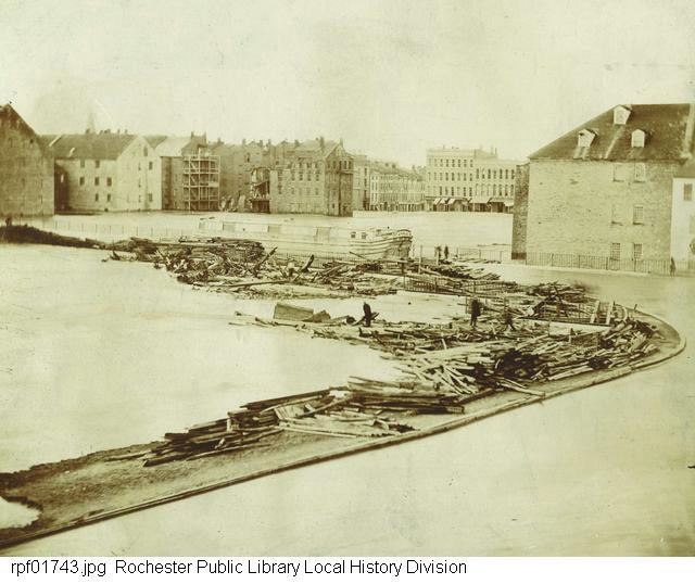 |
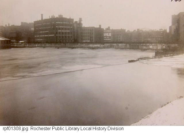
Left: View of Aqueduct during flood of 1865. (photograph : 5 x 7 in.) -- From: Rochester Public Library Local History Division. -- This view looks northeast from Court Street and South Avenue. A canal boat is crossing in the Aqueduct. The river has risen to the level of the aqueduct, and lumber from the Bronson & Hollister lumberyard has blocked the aqueduct arches and threatens to spill over into the aqueduct. Rochester's Great Flood lasted from March 17-20, 1865. It was caused by a long period of cold weather and heavy snowfall followed by a sudden thaw accompanied by rain. The maximum rate of flow of the river in Rochester was estimated at 54,000 cubic feet per second. Damages were said to have exceeded one million dollars. The banks of both the river and the canal overflowed into the city. Small boats were used on some flooded streets. The flood began on a Friday and the river returned to its boundaries within the city on Monday morning. By then, the streets were finally bare. | |
 |
 |
 |
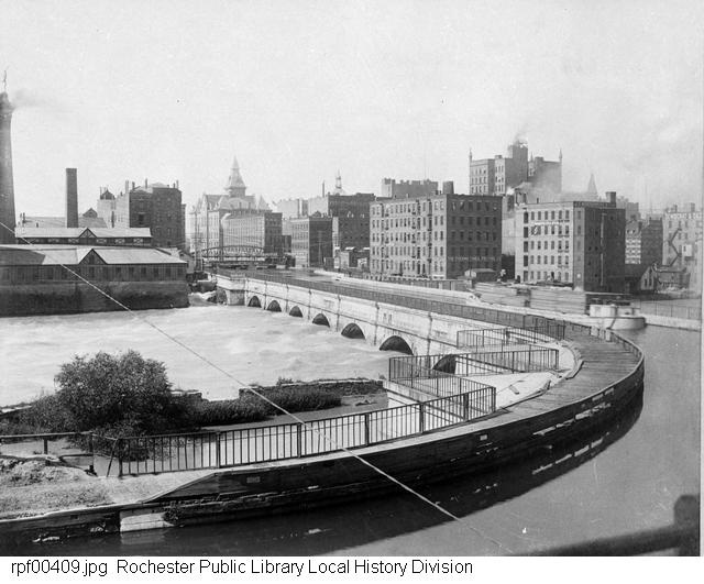
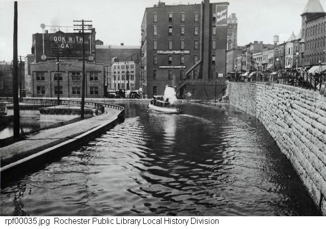
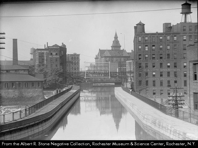
| Erie Canal Aqueduct between 1888 and 1894. (photograph : 4 x 5 in.) -- From: Rochester Public Library Local History Division picture file. -- A view of the Erie Canal Aqueduct, the Genesee River, and downtown Rochester between 1888 and 1894, looking northwest. | [Erie Canal Aqueduct over the Genesee River]. 1890 (photograph : 5 x 7 in.) -- From: Rochester Public Library Local History Division picture file. -- The Erie Canal Aqueduct crossing the Genesee River with a canal boat on the canal. | Erie Canal Aqueduct. Photograph taken October 29, 1892. (negative : glass ; 4 x 5 in.) - From: Rochester Municipal Archives early collection. -- The Erie Canal Aqueduct over the Genesee River, seen from the east end of the Court Street Bridge, looking northwest. |
 |
 |
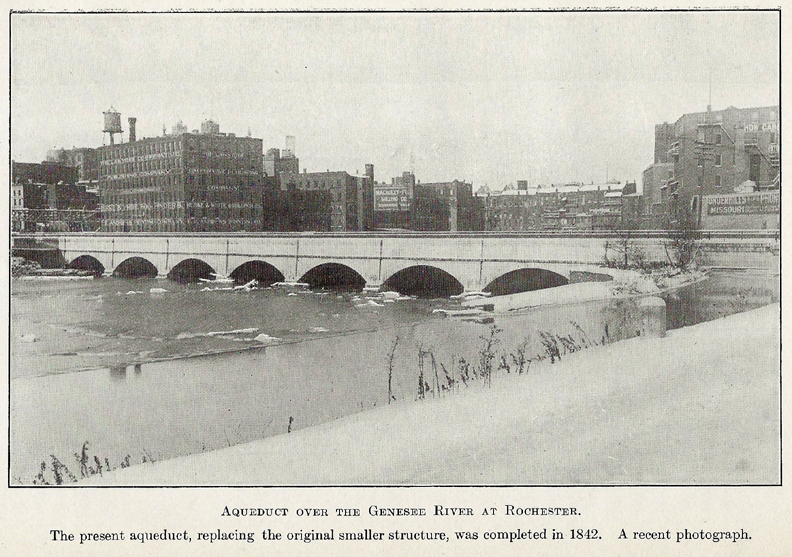 |
| Erie Canal Aqueduct. 1897-1899? (photograph : 7 x 9 in.) -- From: Rochester Public Library Local History Division picture file. -- The Erie Canal Aqueduct, looking west. Note how sharp the curve on the eastern end (foreground) is for turning canal boats. | Flood of 1902. Photograph taken March 3, 1902. (photograph : 5 x 6 in.) -- From: Rochester Public Library Local History Division picture file. -- A view of the Erie Canal Aqueduct, looking north, in high water stage during the flood of March 1902. On March 3 the water in the Genesee River completely filled the arches of the aqueduct. The flood was caused by snow melt. (Contrast this image with the 1905 image to the right and 1906 image below left of the normal river level.) | Aqueduct over the Genesee River at Rochester, 1905 -- From: History of the Canal System of the State of New York ... / by Noble E. Whitford (Albany : Brandow Publishing Co., 1906) -- vol. 1, facing p. 170. |
 |
 |
 |
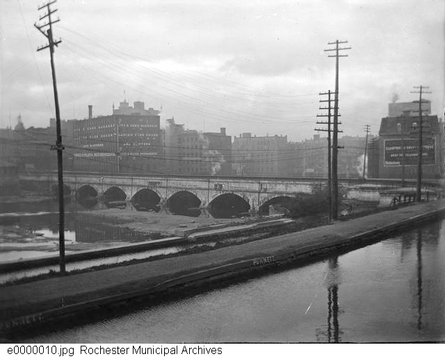
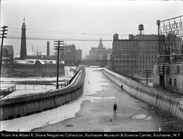
| Erie Canal Aqueduct, looking north. Photograph taken December 4, 1906. (photograph ; 4 x 6 in.) - From: Rochester Public Library Local History Division picture file. -- A view of the Erie Canal Aqueduct, looking northwest. To the left is the Genesee River, while in the distance various downtown Rochester buildings are seen. (Compare this image with that of the river in flood in 1902 above.) | Aqueduct over the Genesee River / photographed by Albert R. Stone in 1908-1910? (photograph ; 5 x 7 in.) - From: Albert R. Stone Negative Collection, Rochester Museum & Science Center. -- The Erie Canal Aqueduct, drained of water for the winter, looking west. | Erie Canal Aqueduct. 1910-1915? (photograph ; 5 x 7 in.) -- From: Rochester Public Library Local History Division picture file. -- At the eastern end of the Erie Canal Aqueduct, looking north. |
 |
 |
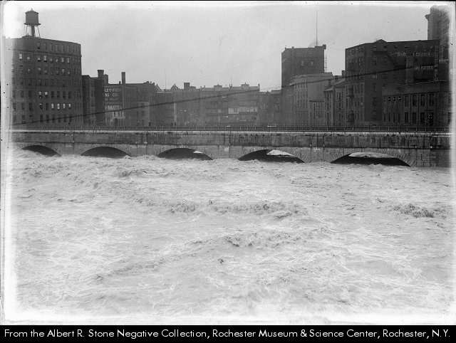 |
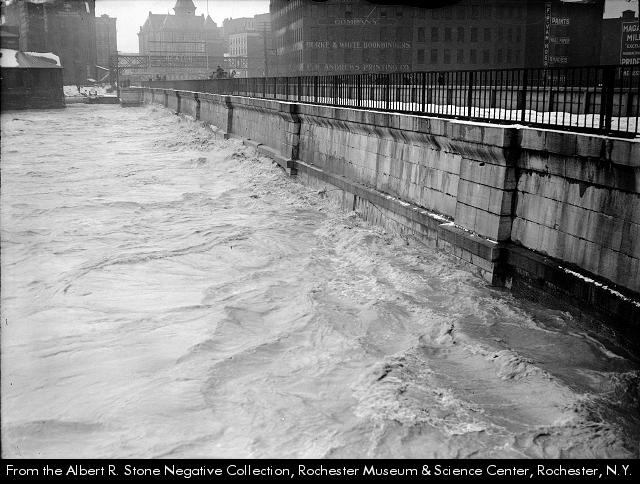
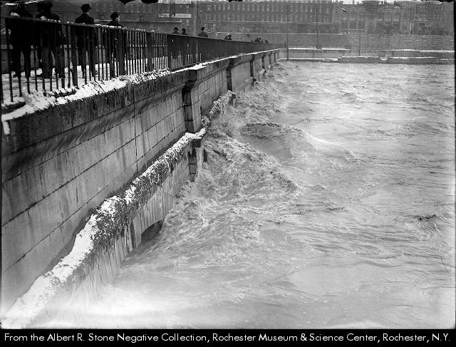
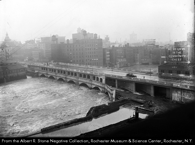
| Aqueduct arches under flood waters / photographed by Albert R. Stone (photograph ; 5 x 7 in.) -- From: Albert R. Stone Negative Collection, Rochester Museum & Science Center. -- The flood waters of the Genesee River cover the arches on the south side of the aqueduct. The view is looking west towards Exchange Street. -- Printed in Rochester Herald, March 29, 1913. | Aqueduct / photographed by Albert R. Stone, 1913? (photograph ; 5 x 7 in.) -- From: Albert R. Stone Negative Collection, Rochester Museum & Science Center. -- Flood waters swirl around the aqueduct near Broad Street ; looking east toward South Avenue. | Genesee River / photographed by Albert R. Stone. (photograph ; 5 x 7 in.) -- From: Albert R. Stone Negative Collection, Rochester Museum & Science Center. -- The Erie Canal aqueduct with high water in the Genesee River. The arches of the aqueduct are still partially above water. The caption states that the deepening of the riverbed has saved the city from the customary flood. Printed in Rochester Herald, May 26, 1919. |
| The above three pictures, and those of 1865 and 1902 above, show the recurring problem of flooding in Rochester, which led to the construction of the Mount Morris dam south of Rochester, near Letchworth State Park, between 1948 and 1952. "Records show that the Genesee River Valley and the City of Rochester had experienced flooding since 1800. The flood of 1865, which developed flows exceeding 24 million gallons per minute, resulted in massive destructions with flows equating half the flows of Niagara Falls. Severe floods occurred every seven years between 1865 and 1950." (From: Wikipedia, Sept. 14, 2010). | ||
 |
 |
 |
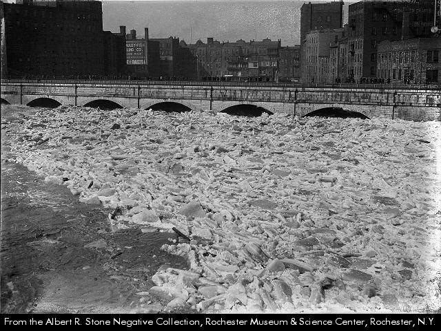
| More ice jams in the Genesee River / photographed by Albert R. Stone. (photograph ; 5 x 7 in.) - From: Albert R. Stone Negative Collection, Rochester Museum & Science Center. -- Most of the river is covered with jumbled chunks of ice, and the arches under the Erie Canal Aqueduct are almost filled with ice, presenting a classic ice jam. The photograph was taken from the Court Street Bridge. -- Printed in Rochester Herald, March 13, 1920. | Erie Canal Aqueduct. 1920-1922? (negative ; 4 x 5 in.) -- From: Rochester Municipal Archives modern collection. -- A view of the Erie Canal aqueduct over the Genesee River, looking west. | Aqueduct Street [Rochester] / photographed by Albert R. Stone, October 29, 1921. (photograph ; 5 x 7 in.) -- From: Albert R. Stone Negative Collection, Rochester Museum & Science Center. -- Aqueduct Street from 29 Main Street East south to the Erie Canal, First Ward. Printed in Rochester Herald October 29, 1921, and reprinted May 27, 1923. |
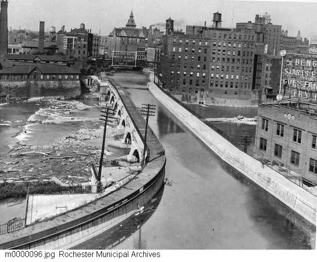
With the construction of the Barge Canal in 1918, the canal was moved south of the city of Rochester. Since the Genesee River Aqueduct was no longer needed, a road deck for Broad Street was built atop the aqueduct in 1922-1924, and the aqueduct was modified internally to carry the tracks of the Rochester Subway (or Rochester Industrial and Rapid Transit Railway) from 1927 to 1956. The Broad Street Bridge deck was rebuilt as it stands today in 1973-1974. Below are images of the conversion of the former Erie Canal Aqueduct to the foundation of the Broad Street Bridge.
 |
 |
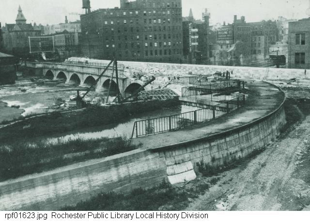 |
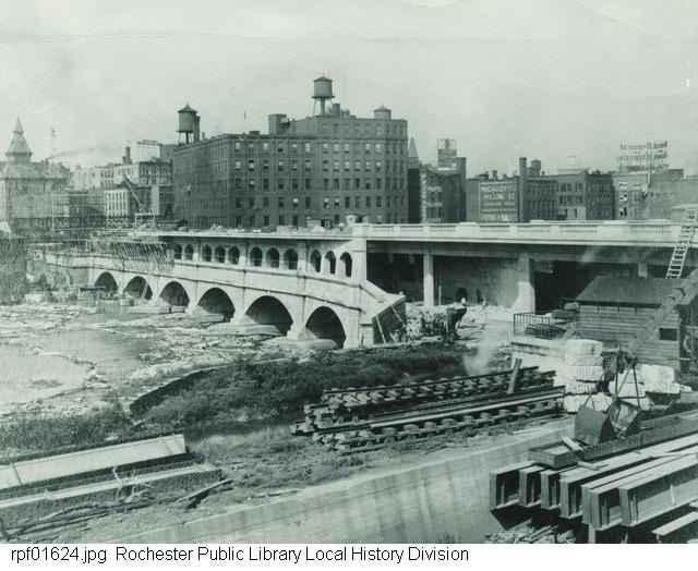
| Broad Street Bridge construction. (photograph : b&w ; 7 1/2 x 9 1/2 in.) - From: Rochester Public Library Local History Division picture file. -- A view of the Broad Street bridge under construction, looking north. The bridge was built upon the limestone foundation of the former Erie Canal aqueduct. Handwritten on reverse of photo: 9/29/1922. | Aerial of Aqueduct - Broad Street Bridge construction, seen from the air. 1922 (negative : glass, b&w ; 4 x 5 in.) - From: Rochester Municipal Archives early collection. -- An aerial view of the Erie Canal Aqueduct, looking south from above the Main Street Bridge. The reconstruction of the old aqueduct can be seen on the left (east) end. | Subway construction at Aqueduct. 1922 (photograph : b&w ; 5 x 7 in.) - From: Rochester Public Library Local History Division picture file. -- The Rochester Subway under construction at the site of the former Erie Canal Aqueduct. The view is to the northwest. The Genesee River is to the left. |
 |
 |
 |
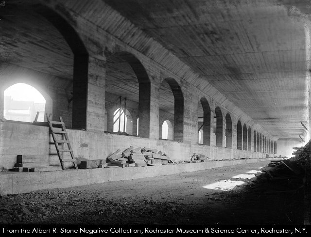
| Rochester Subway construction at Aqueduct. 1924? (photograph : b&w ; 8 x 10 in.) - From: Rochester Public Library Local History Division picture file. -- The construction of the Rochester Subway at the former Erie Canal Aqueduct. The view is to the northwest. | Aqueduct's arches look like medieval cloister / photographed by Albert R. Stone. 1924? (photograph : b&w ; 5 x 7 in.) - From: Albert R. Stone Negative Collection, Rochester Museum & Science Center. -- The sun streams through the open arches of the Aqueduct over the Genesee River. The center arches divide the new "subway street" bridge into two lanes, allowing the Interurban trains to run where Erie Canal boats once did. | Aqueduct becomes Broad Street Bridge / photographed by Albert R. Stone. 1924? (photograph : b&w ; 5 x 5 in.) - From: Albert R. Stone Negative Collection, Rochester Museum & Science Center. -- Work proceeds on the Broad Street Bridge. The lower level, which will become the subway, has been opened to ground level at the east end of the bridge. |
 |
 |
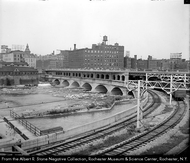 |
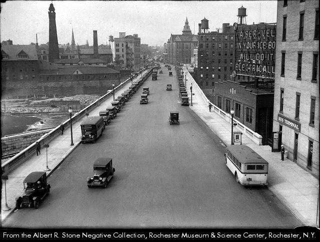
| Side view of Broad Street Bridge with cables. 1924? (photograph : b&w ; 5 x 7 in.) -- A side view of the Broad Street Bridge during the reconstruction that transformed the Aqueduct into Broad Street and a "subway bridge". The cantilevered section above the arches is the pedestrian walkway on the upper level. | Broad Street Bridge. 1925-1930? (photograph: b&w; 5 x 7 in.) -- A view of the top of the completed Broad Street Bridge looking toward City Hall. | Aqueduct with subway tracks. 1929? (photograph: b&w; 4 x 5 in.) -- The trolley tracks can be seen curving to enter the lower level of the former aqueduct as it crosses the Genesee River. The Broad Street Bridge occupies the upper level. Printed in Rochester Democrat & Chronicle, July 15, 1929. The caption reads, "Trolleys whiz where canal boats used to glide". |
| [All three images photographed by Albert R. Stone. - From: Albert R. Stone Negative Collection, Rochester Museum & Science Center.] | ||
 |
 |
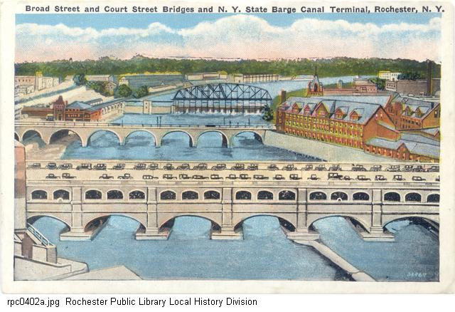 |
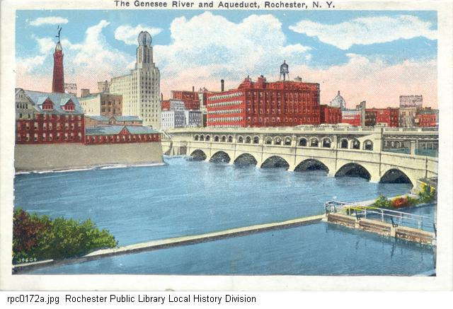
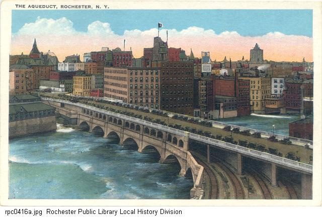
| "The Genesee River and Aqueduct, Rochester, N.Y." (Postcard ; no publisher information) -- approximately 1925-1930? | "The Aqueduct, Rochester, N.Y." [Broad Street Bridge and Subway] (Postcard ; no publisher information) -- approximately 1925. | "Broad Street and Court Street Bridges and N.Y. State Barge Canal Terminal, Rochester, N.Y." (Postcard ; no publisher information) -- approximately 1925. |
Visit Rochester Images
for more pictures of the Erie Canal and the City of Rochester and environs.
(Monroe County Library System / Local History / Digital Collections)
http://www.eriecanal.org/Rochester-2.html

