General Scheme of Supply -- Discussion of Water-Supply Requirements for a Canal -- Supply for Western Portion of Erie Canal -- Supply for Rome Summit Level -- Old Sources of Supply for Rome Level -- A New Source, Delta Reservoir -- Its Characteristics and Size -- Another New Source, Hinckley Reservoir -- Its Characteristics and Size -- Still Another Source Considered -- Supply for the Champlain Canal -- Supply for the Oswego canal -- Supply for the Cayuga and Seneca Canal.
The planning of an adequate water-supply for a canal as large as the new waterway system in New York state, while not the most difficult task, was one which required thorough and extended study. This task was much simplified, however, by work which had preceded it, for during many years of the old canals the State had been building up a large system of reservoirs and feeders and with but few exceptions these were retained for the new canals.
Throughout considerable portions of their length the several branches of the Barge canal utilize existing natural streams, making them canalized rivers, and in general the ordinary flow of these streams is sufficient to maintain the requisite depth of water in the levels between the locks and also to supply the water required for lockage and incidental purposes. In other portions of the route, the canal follows what are called low-level lines, using the stream valleys although not always lying actually in the stream beds. In this respect the new canal differs from the old, which as a rule was built on a level somewhat above the streams that it paralleled throughout most of its length. The adoption of these low-level and canalized-river lines also greatly simplified the problem of water-supply, but they were not chosen for that reason alone; they have other advantages and these were uppermost in prompting their selection.
Water is required in operating a canal for six main purposes, namely, to fill the canal prism, to fill the lock chambers, to provide power for operating lock machinery, to provide power for lighting the vicinity of the locks, to replenish loss due to unavoidable leakage through gates, culverts and turbines at locks, and to replenish loss in the levels between the locks.
In discussing these purposes it may be said that an independent water-supply for filling the canal prism is needed only in land lines and then only at the opening of navigation or after water has been drawn from the levels for some reason, such as making repairs. In river lines, the natural flow of the stream will of course fill the prism.
Next in importance to filling the canal is the use of water for lock operation. A canal is essentially an inland transportation line in which the grades are overcome by water-power. That the energy is applied through the buoying power of the water makes it no less an application of water-power. Considering the mechanism that would be necessary to lift a boat mechanically without a lock, it is probable that by this means there would be attained little if any greater net efficiency than that secured by the usual lock. In addition the lock has the advantage of simplicity, quick operation and avoidance of strain on the boat. There may be a waste, of course, occasioned by the order in which boats pass a lock. If they go up and down alternately, then one lockful of water will suffice for lifting one and lowering the next. If boats run in the same direction in sequence, then a lockful is required for each boat or each fleet of boats going up or down. But even allowing for the waste of energy in lowering boats when a separate filling or emptying of the lock is required, the canal lock is a fairly efficient water-driven machine.
The amount of water required for a lock varies not only with the height of the lift but also with the amount of traffic. And for a given amount of traffic the water-supply varies according to the size of boats, since large and small boats use an equal amount of water for lockage, and also according to the manner in which they pass the locks, whether singly or in groups and whether lockages in the same direction are made in sequence or alternate with lockages in the opposite direction.
Of the third and fourth purposes of the water-supply, those of providing power to operate and also to light the locks, little need be said in amplification. The old locks were generally hand-operated, but for a large, modern canal such method can be considered only in the exigency of disabled electrically-driven machinery. In studying the Barge canal problem it was found best to provide a separate source of power at each of the locks, except in the few cases where locks are so near together as to be easily supplied from one power-plant without long transmission lines.
The loss of water in the levels between locks occurs chiefly in the land lines and includes seepage through embankments, waste over spillways, evaporation from water-surfaces and transpiration through aquatic plants. In the river lines there is no loss over spillways and little from seepage.
The critical points in supplying water to canals are usually the summit levels. Although lower levels may demand more water, it is usually more readily obtainable. Proceeding downward from a summit the supply required at any lock may be taken -- to use mathematical terms -- as the sum of the losses between the source of supply and the lock, plus the water needed at the lock, minus the natural inflow between source and lock. Thus it appears that the necessary supply may vary greatly from point to point. In providing water for a summit level it is necessary, therefore, to obtain a supply adequate for the points of greatest demand on both sides of the summit. Generally speaking the lock of highest lift is the point of greatest demand. Whether the lock of highest lift is near to or remote from the source of supply, and the volume of intermediate losses or acquisitions, govern the amount that must be supplied at the summit.
From this description it is seen that the problem of estimating the water-supply for the Barge canal was rather complicated and embodied several intermediate factors. It was necessary, therefore, to allow a liberal excess, or reserve, as a factor of safety.
On the new Erie canal the descent is downward from Lake Erie to the confluence of Seneca river, which flows from the west, and Oneida river, which comes from the east, where they join to form Oswego river and run north into Lake Ontario. From this junction of Seneca and Oneida rivers, called Three River Point, there is a rise to a summit level that stretches between New London and Whitesboro and is known as the Rome summit level. Thence easterly there is a descent to the Hudson river. It is seen, then, that there is one true summit level, that at Rome, and one half summit, that extending easterly from Lake Erie.
The largest independent supply required for any portion of the Barge canal is that needed at the western end. Fortunately an almost unlimited supply is available by tapping Niagara river at Tonawanda. The lock of highest lift that is fed from this source is located near Pittsford, a little east of Rochester. It is necessary, therefore, to draw enough water from the Niagara river to operate this lock after allowing for the loss and waste in nearly one hundred miles of canal. Sufficient water from the Niagara to furnish an adequate supply at the Pittsford lock, however, is enough for the tandem locks at Lockport, which have a combined lift of forty-nine feet.
In order to carry the water in requisite volume easterly from Niagara river it is necessary to give the canal bottom the proper slope in the levels between Tonawanda and Lockport and between Lockport and Rochester. In doing this provision has been made for carrying at least 1,237 cubic feet of water per second. It has been proved in both theory and practice that a moderate current in the direction of greatest traffic in a canal is advantageous. The eastward current resulting from the flow of Niagara river feed-water through the western portion of the canal as about two-thirds of a mile an hour. As the greatest traffic on the Barge canal is eastbound, the current at the western end is beneficial as well as unavoidable. With the ample water-supply from the Niagara river it is unnecessary to draw any water from former feeders in this territory, such as the Oak Orchard creek at Medina and the Genesee river at Rochester.
Although the amount of water required for the Rome summit level is less than that for the western section, the difficulties of securing an adequate supply are greater than for any other portion of the Barge canal. Throughout the existence of the State canals this part of the system has always presented the most difficult problem in water-supply and this has led to the building of numerous reservoirs among the hills to the south of the canal and also within the Adirondack region on the north. A potent factor in determining the question in 1836 of building the Black River canal was its ability to bring the waters of the northern forests to the needy Erie, the very name given by law -- the Black River Canal and Erie Canal Feeder -- indicating one of its chief functions. As we have said elsewhere, doubtless this canal would have been abandoned along with the other laterals but for necessity as a water-supply feeder. Because of this difficulty in supplying water there have been attempts in later years to eliminate the Rome summit level and these have caused investigations to be made for a line of continuous descent from Lake Erie to the Hudson, but all construction along such a line has seemed to costly to be practicable.
The Rome summit level of the new canal extends from lock No. 20, near Whitesboro, to lock No. 21, which lies between the hamlet of New London and Oneida lake. The Rome summit level of the old canal reached from Utica to Syracuse and was about fifty-six miles long. Its elevation was nearly ten feet higher than that of the new level. The use of the shorter summit at a lower elevation reduces the difficulties attendant upon securing an adequate water-supply.
It happens that a lock of 21 feet lift is situated near the easterly end of the new Rome summit level. Water sufficient for operating this lock, along with the natural supply drawn from the Mohawk river and its tributaries, is adequate to operate the canal throughout its length easterly to the Hudson river. At the westerly end of the summit the canal descends through two locks, each of 25 feet lift, down to the level of Oneida lake, so that a supply sufficient for the terminal lock is all that has to be provided in that direction.
The sources of supply for the new Rome level include substantially all of those used for the old level and two new sources in addition. The old supply north of the canal came from the headwaters of the Black river above Forestport. The waters reached the Erie canal through a feeder to Boonville and the Black River canal thence to Rome. Whatever water was spilled in this passage was caught in the Mohawk river and delivered to the Erie through a short feeder, also at Rome. For supplying the new canal there have been retained the Black River canal, the Boonville feeder and the system of reservoirs above Forestport. The Mohawk river feeder at Rome is no longer needed, since the whole river is taken into the canal and carried for several miles.
The old sources south of the canal are also retained. These consist in part of streams which the old canal crossed -- Oriskany, Oneida, Cowassalon, Chittenango, Limestone and Butternut creeks. To secure this supply, diverting dams and feeders had been constructed and on the headwaters of some of the streams reservoirs had been built. After the Chenango canal was abandoned some of its water-supply, which came from reservoirs on the headwaters of the Chenango river, a part of the Susquehanna drainage basin, had been retained, reaching the Erie canal feeders through diverting channels. This source is among these retained for the Barge canal. To bring water from these sources on the south to the new canal is has been necessary to retain as a navigable feeder that portion of the old canal which lies between New London and the Orville, or Butternut creek feeder, which is situated only a few miles east of Syracuse. A new junction lock at New London connects the two waterways.
The new sources of supply, developed in connection with the Barge canal construction, are the headwaters of the Mohawk river and the West Canada creek. The Mohawk, to be sure, under the old arrangement could be diverted to the canal through the feeder at Rome, but as there were no storage facilities, only so much was available as the natural flow of the stream happened to furnish at any particular time. The building of reservoirs on these headwaters has added two new lakes to the map of the state. Large artificial lakes, built for the supply of navigable canals, are relatively few in number and, if we ignore works like the Indian River lake, partially natural bodies of water, we are not aware of any in existence comparable in size with those constructed at Delta and Hinckley for the use of the Barge canal. But notwithstanding this fact the basin at Delta holds less than one-twentieth part of the capacity of Salt river reservoir, in Arizona, and covers little more than one-third the area of the Ashokan reservoir of the New York city water works. The Ashokan reservoir, by the way, wiped out seven villages, while Delta reservoir covers the site of only one.
The waters of the upper Mohawk are held in storage at Delta reservoir, or Delta lake, as the people of the vicinity prefer to call it. This is situated about five miles north of Rome and occupies a basin formed by an enlargement of the river valley just above a rock-walled gorge, the base of which is about six hundred feet wide at the site chosen for the dam, while its eastern wall, against which the river formerly flowed, rises precipitately and attains in places a height of one hundred feet. This bluff was known locally as the "Palisades." The hills surrounding the basin are arranged on the general scheme of a triangle with one vertex pointing upstream and this suggested to the first settlers the triangular Greek letter delta, the name they chose for the village the reservoir has now submerged. The waters of the new reservoir bring out even more conspicuously than did the hills this peculiar shape of the valley.
It is of interest to notice that in building the Delta reservoir the engineers were merely restoring an ancient glacial lake. In this respect it is like many of the natural basins which have been reoccupied by reservoirs in modern times. Before the reservoir was filled some of the shore lines of the ancient lake were very easily discernible. Excavations for the dam disclosed a buried gorge, pot holes and other evidences of the erosion of the glacial period.
The dam which holds back the waters in this reservoir is about 1,100 feet long, with a spillway 300 feet long near its center, and has a masonry content of about 90,000 cubic yards. Its height is a hundred feet from crest to lowest foundation. The concrete apron is ten feet below the river bottom, so that a permanent pool of that depth is maintained to act as a water-cushion to break the erosive force of the water in its fall of about seventy feet to the surface of the pool. The reservoir has an area at crest level of 4 1/3 square miles, a maximum depth of 70 feet, an average depth of 23 feet and a capacity of 2,750,000,000 cubic feet. The area of the tributary watershed is 137 square miles. The reservoir submerged ten miles of highways, seven canal locks and one aqueduct and required the removal of 295 buildings. The relocation of nearly two miles of the Black River canal, including four new locks and an aqueduct, was necessary. Incidently the reservoir has considerable influence in mitigating disastrous flood conditions in the lower Mohawk valley.
The second of these two new sources of supply is West Canada creek. This stream reaches the Mohawk valley in the vicinity of Herkimer, too far below the Rome summit level to be of any material use. To make it available where needed, therefore, a diverting channel about 5.7 miles long takes the water after it has come from the impounding reservoir some five miles by way of the creek and turns it across a rather low divide into the channel of Nine-Mile creek, whence it flows by natural stream to the Barge canal, reaching it near Oriskany.
The reservoir, which is known by the name of the village near which it is situated, Hinckley, is about twenty miles north of Utica and lies in the foot-hills of the Adirondack mountains. The topography of its watershed of 372 square miles is rugged and varies in altitude from about 1,165 to 3,100 feet above sea-level. The drainage basin of this creek, like that of the upper Mohawk, is located in the region which has the maximum precipitation of the state, a precipitation which is exceptionally high during the winter months, in the form of snow.
No constricted gorge, where a short dam might be built, was available on the site of this reservoir. The dam has a total length of 3,700 feet, of which there is a 400-foot masonry section, embodying gate chambers and spillway. The major, or earthen, portion of the dam has a concrete core wall running through most of its length. The masonry content of the dam is 110,020 cubic yards, while there are 611,200 cubic yards of embankment in the earthen section. The masonry has a maximum height of 82 feet above rock and the overfall at the spillway is 61 feet. The maximum height of the earthen dam is 56 feet above the natural surface.
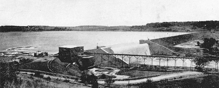
Dam at Hinckley reservoir -- on the headwaters of West Canada creek. The impounded waters reach the Rome summit level of the canal after a passage of nearly 20 miles and a transfer from the West Canada to the Nine-Mile creek watershed through an artificial diversion channel. The long portion in the view is the earthen section; nearer are the masonry spillway and gate chamber. At the near end appears a runway for logs.
The reservoir forks into two parts, which have a combined length of about thirteen miles but no great width, only about a half mile. Its area is 4.46 square miles and its capacity 3,445,000,000 cubic feet. The maximum depth at crest level is 75 feet and the average depth, 28 feet. It necessitated the removal of 209 buildings, which made up parts of three villages, and it submerged seven miles of highways. This reservoir too is of much value for flood regulation, the maximum rate of flood discharge being very materially reduced.
During the early stages of study for the Barge canal water-supply a third new source was considered and careful surveys were made. The site of the proposed reservoir was at High Bridge, Onondaga county, on Limestone creek. But as the studies progressed it became apparent that the canal would not need an added supply from this source and so the plan was dropped, to be taken up again if necessity requires.
The water-supply for the other enlarged canals, the Champlain, the Oswego and the Cayuga and Seneca, presented problems of little moment. The Champlain canal has a summit level on the divide between the Lake Champlain and Hudson river basins. The corresponding summit of the old canal has been supplied by a feeder twelve miles long, which takes its water from the upper Hudson. This same feeder, the Glens Falls feeder it is called, after some improvements, supplies the needs of the northern portion of the new Champlain canal, while the southern portion lies in the channel of the Hudson river.
The Oswego canal begins at Three River Point. Here Oneida and Seneca rivers unite, bringing their natural flow and also part of the supplies from the Rome level reservoirs and Lake Erie. As the canal is chiefly the Oswego river, its needs are much more than met by the natural stream flow and the added Erie supplies which reach Three River Point.
Seneca and Cayuga lakes, lying at the heads of their respective stretches of the Cayuga and Seneca canal, are natural reservoirs which not only supply all the water this canal needs but also augment the supply of the Erie branch between its junction with the Cayuga and Seneca canal and Three River Point.
http://www.eriecanal.org/Texts/Whitford/1921/chap24.html