Siphon lock at Oswego. At the junction of Barge canal and Lake Ontario navigation. The only siphon lock in America and the largest lock to which the siphon principle has been applied.
Desire to Share in Original Canal Benefits -- Like Desire to Share in Barge Canal Benefits -- Black River Canal Extension: History of Building Black River Canal: Early Arguments: Previous Agitation for Extension: Recent Agitation: Surveys and Estimates: Attempted Authorization: Repairs to Existing Canal -- Chemung Canal Reconstruction: Effect of Revolutionary Expedition: State Canal Built: Vicissitudes of Waterway: Private Canal Built: Both Parts Abandoned: Recent Survey and Estimate -- Glens Falls Feeder Conversion: Topography and History: Retained as Barge Canal Feeder: Survey and Estimates: Discussion of Expediency -- Jamaica Bay-Flushing Bay Canal: Topography: Influence of Jamaica Bay Terminal Agitation: Route and Three Types of Canal Discussed: Estimates: Benefits Claimed -- Newtown Creek-Flushing Bay Canal: Route: Estimate: Benefits Claimed -- Summary of 1913 Estimates -- Barge Canal Branch, Seneca River to Auburn: Route: Estimate: Analysis of Cost of Carriage -- Improvement, Tonawanda to Buffalo: Navigation against Current Involved: Investigation Conducted: Report against Project: Estimates -- Some Principles Governing Canal Economics.
It has been true of most great movements that they have engendered a spirit of emulation. And when these movements have had large promise of beneficence, this spirit has been augmented by the stimulus of a strong desire to share in the benefits. Thus in the case of our own canal, the original Erie, the great pioneer of American waterways, its completion and early success was followed by a veritable frenzy for canal-building throughout the country. In New York state this zeal manifested itself in a flood of petitions to the Legislature for the opening of waterways, in the survey of hundreds of miles of proposed routes and the building of several lateral canals and in the incorporation of more than sixty private canal companies. One act alone, what is known as the "great canal law" of 1825, ordered the surveys of seventeen contemplated canals, covering a distance of over twelve hundred miles. Within the first decade after the opening of the Erie and Champlain canals six more State canals were built and during the next four years still four others were authorized.
So again, to share in the promised good of the Barge canal, the people of several sections of the state have sought and obtained surveys and investigations of various routes along which they have desired to build additional branches to the new canal system. On none of these projects, however, has the agitation passed beyond this preliminary stage and the reason for this is not hard to find. Primarily the need for waterway enlargement to Barge canal dimensions was felt for the Erie canal alone, but before the improvement of that branch was authorized two other canals were included in the scheme, and this was done, as we have seen, partly for the purpose of securing united support for the whole canal movement. Then a few years later a fourth branch was added, so that now the four main State canals, the four that on previous occasions had been deemed worth enlarging, have been increased to uniform Barge canal dimensions. Although these other examinations, which we are about to consider, have been made and in some cases careful surveys and estimates and tentative plans have been added, there has not existed sufficient public demand to push any of them to the point of very serious consideration. Doubtless our experience with our abandoned lateral canals has taught us caution, and also there seems to be abroad a better appreciation of the principle now generally recognized by those conversant with the subject, that waterways which do not connect large industrial centers nor reach the source of some extended natural supply are not worthy of construction.
We would not say, however, that any of the proposed routes which the State has ordered to be examined within the past few years should be rejected because of adverse decision under the principle just enunciated. That is not a question for us to determine. Perhaps the days to come may see canals built with profit along some of these lines. But historically these investigations are of interest to us, irrespective of any future prospects, and we shall study each in turn with some care. Also, outside the borders of New York state but connected more or less directly with the Barge canal system there have been proposed other important canal projects. A little later these too will engage our attention, but for the present we shall confine our thought to our own particular schemes.
The first of the projects to receive legislative authority for investigation was that along the course of the Black river from Carthage to Lake Ontario. In 1911 the Legislature (by chapter 190) directed the State Engineer to make a survey and prepare plans and estimates for improving the Black river for navigation between the State dam at Carthage and Sacketts Harbor, on Lake Ontario. To understand this project we need to know a little of what has gone before in this region.
The story of the attempts to provide waterways for this North country, the failures as well as the successes, is most interesting. Like other branches of the State system the career of the Black River canal and its adjuncts has been rather checkered. First came the incorporation of the Black River Navigation Company. In 1810 this body was given power to improve the river from Lake Ontario to Brownville, a village lying some four or five miles up the river. It is recorded in the annals of Jefferson county that this company built the necessary wooden locks at Dexter, near the lake, and that later, in 1828, these were rebuilt of stone to accommodate a steamer named "Brownville," which had a length of 80 feet, a beam of 20 feet, a hold depth of 6 1/2 feet, a capacity of 100 tons and engines of 35 to 40 horse-power, and was built in the village of Brownville. It was the intent to use this vessel for traffic to and from Ogdensburg, but after having passed the locks with difficulty she was burned to the water's edge on her first trip.
Among the canal surveys ordered by the "great canal law" of 1825 were two to connect the Erie canal with the St. Lawrence river at Ogdensburg. Because the law was somewhat obscure as to its meaning the engineer who made the surveys, James Geddes, one of the best known of the Erie canal engineers during its preliminary survey and construction stages, ran lines over three routes, one from Herkimer to the upper waters of Black river and thence to the St. Lawrence near Ogdensburg, another from Rome through Boonville to what is known as High falls on the Black river, thence in the river for forty miles to Carthage and beyond that north through the village of Gouverneur and down the Oswegatchie river to Ogdensburg, and the third from Fort Bull, a little west of Rome, up Fish creek valley, through Camden, and on north across Salmon and Black river valleys into West creek valley and thence on to Indian river valley and down that valley and through Black lake to Ogdensburg. [original text has "Ogdensburgh"].
Like many another of these early canal surveys, the construction of the waterway did not follow. In this case, however, the canal was built eventually. The route selected was substantially the second of those just described, but terminating at Carthage. In 1836 this was authorized; between 1838 and 1855 the main canal was constructed. It left the Erie canal at Rome and ran north, following the Mohawk valley as far as that was available; it approached the Black river valley at Boonville, where it attained its summit level; continuing it descended to the north, paralleling the Black river and finally dropping into that stream at the village of Lyons Falls. This canal was supplied with water through a feeder from Boonville to Forestport, which was built between 1838 and 1848. The work of making the river navigable between Lyons Falls and Carthage was begun in 1854 and finished in 1861. This portion of the waterway has been known in canal history as the Black River Improvement; it its natural state it was almost capable of being used for navigation.
The number of locks on the Black River canal is unusually large. Between Rome and Lyons Falls, a distance of about 35 miles, there are 109 locks, or an average of more than three to the mile. This peculiarity of contour led to some very interesting investigations before the canal was built. The plan of placing boats on cradles and running them up inclined planes on rails was seriously considered. This was the only New York canal for which such a plan was ever contemplated.
The Black River canal is still a part of the State system, but only a portion of it has been much in use of late. From Boonville south it is open for traffic. Years ago the river navigation was cut off by reason of the dilapidated condition of the connecting lock. Until recent repairs the section between Boonville and Lyons Falls was for years in such condition that it was seldom used.
When petitions were being presented to the Legislature for the building of the Black River canal the large lumber supply in this vicinity and the importance of this section of the state as an agricultural, dairy and grazing region were among the chief arguments in its support. Another reason for constructing this canal was the need of the water it could bring to the Erie canal. Mr. Geddes in the report of his survey in 1826 had cited this possibility and without doubt this proved to be the strongest reason of all those advanced. It is probable that the canal would have been abandoned long since, except for this need. In fact in 1874 the constitutional restriction forbidding its sale was removed from this branch along with other lateral canals subsequently abandoned and only a favorable report by a special commission of expert investigators saved it from the fate of the others. Moreover, that the value of this canal as a water feeder was recognized from the beginning is shown by the official name bestowed upon it by the authorizing law, which states that it shall be known as "The Black River Canal and Erie Canal Feeder."
During the many years since the Black River canal was begun the State has been engaged in constructing an extensive system of reservoirs in the Adirondack forest, those on the headwaters of the Black river being used for storing a canal supply, while others replace the amount of water diverted from the Black river for canal purposes. The Black River canal is the channel through which the canal supply reaches the Erie branch. And now these reservoirs and the connecting canal have been retained for the Barge canal and in addition two vastly larger reservoirs have been built close to the old system.
Almost as soon as construction work had begun on the Black River canal, agitation was started for extending the waterway in various directions, and among the routes proposed at that time was one which was substantially the same as that surveyed in 1911 and 1912. In response to petitions in 1838 and again in 1839 the Legislature of the latter year made provision for surveying these routes. In 1840 the report of the engineer, Edward H. Brodhead, was submitted to the Legislature. The estimated cost of the proposed canal of that early day becomes interesting in comparison with the estimates of the recent survey. Of course the two are not truly comparable, since the sizes and character of waterway and the conditions of building are so widely different. A brief summary of Mr. Brodhead's estimates shows the following:
Carthage to Sacketts Harbor -- Length, 31 1/4; 50 locks, 480 feet lockage, total cost with stone locks, $1,444,614.28, with composite locks, $1,230,629.28, with wooden locks, $1,040,027.28.
Carthage to Dexter -- Length, 27 3/4; 50 locks, 480 feet lockage, total cost with stone locks, $1,394,036.32, with composite locks, $1,180,176.02, with wooden locks, $988,943.02.
Carthage to French Creek (now Clayton) -- Length, 34 1/2 miles; 48 locks, 480 feet lockage, total cost with stone locks, $1,327,874.67, with composite locks, $1,086,585.67, with wooden locks, $894,108.67.
Carthage to Ogdensburg -- via Oxbow and Oswegatchie river -- Length, 77 1/8 miles; 54 locks, 527 feet lockage, total cost with stone locks, $1,681,150.41, with composite locks, $1,417,410.41 with wooden locks, $1,179,910.41. Via Gouverneur -- Length 72 3/8 miles; 64 locks, 621 feet lockage, total cost with stone locks $2,515,199.87, with composite locks, $2,217,566.87, with wooden locks, $1,948,150.87. Via Little Bow Landing and Oswegatchie river -- Length, 72 3/8 miles; 53 locks, 517 feet lockage, total cost with stone locks, $1,954,274.48, with composite locks, $1,688,433.48, with wooden locks, $1,447,230.48.
The introduction of a bill to build the extension followed the presentation of the report, but it was defeated upon final vote. The Assembly, however, passed a resolution asking the canal commissioners for a report on the probable amount of revenue to be derived from the proposed extension and also the probable increase which might be expected from the canal already under construction if the extension were added. At the next session, 1841, the commissioners made a report as directed, but it was evasive and imparted no satisfactory information. A bill for the undertaking introduced that year did not emerge from committee and although the agitation continued for a while, in a few years the whole matter dropped out of sight.
One of the reasons urged at the time for the extension is worth a brief glance. It was argued that from a military point of view it was necessary that the Black River canal should extend to Lake Ontario, since the British Government, at considerable expense, had within a few years constructed the Rideau canal, which gave them safe passage to the eastern end of the lake through the interior of Canada. This short extension in New York, it was urged, would enable the United States to maintain its position in time of war at a great saving of expenses in the transportation of armaments and stores. In a way this argument was good, especially at that time. Of course we already had entrance into Lake Ontario by way of the Oswego canal, but there is a large reach of border at the eastern end of the lake north of Oswego. It is a fact that during the War of 1812 Sacketts Harbor was considered so important a post that large amounts of military stores were carried thither overland through the Black River country at an expense, it is said, of more than two million dollars.
But to come to the subject immediately in hand -- the recent agitation for a canal of modern size between Carthage and Lake Ontario. About 1911 the people of northern New York are said to have become much aroused over the lack of transportation facilities in their territory, there being only one railroad within a region of considerable extent. They could see but little prospect of further development unless better means for transportation were afforded and they had little or no hope that these increased facilities would come through the extension of the existing railroad or through the building of competing lines. Their deliverance, therefore, from a condition that was rapidly becoming acute seemed to lie in the repair and extension of the Black River canal. Once this idea took hold of the people of this region they all became enthusiasts for a new canal -- the scheme to include not only substantial repairs to the existing canal, which stretched from Rome to Carthage, but also an extension, to have Barge canal dimensions, from Carthage to Lake Ontario. They urged their representatives in the Legislature to work toward this end and the result was an appropriation of $50,000 for repairing the old canal between Boonville and Carthage and also a sum for making a survey of the proposed extension.
It had been learned from a statistical survey of the region that there was at that time an annual in-bound and out-bound traffic of a million and a half tons suitable for canal carriage. The main force impelling the people to seek new transporting facilities, however, was a desire to expand commercially. Development was at a standstill and industrial growth must cease, they declared, unless better means for carrying their products should be afforded. This is largely an agricultural and grazing country and also the manufactures are of considerable importance, particularly the making of paper. The mineral resources also are of no mean proportions. There abound high grade magnetic iron ore, iron pyrites, marble, limestone, sandstone and granite and in smaller quantity there are zinc, lead and hematite. Large development along all these lines, agriculture, manufacturing and mining, was probable, the people thought, but it all seemed contingent on better transportation.
Although the appropriation for the State Engineer's survey of the new route was not large the investigation was thorough and the resulting estimate from tentative plans reasonably accurate. Every feasible route or portion of route was surveyed and estimates made along each, so as to allow a selection of the best. The question of water-supply was carefully studied and the estimates included amounts for suitable storage reservoirs and feeders. Care was taken to include sums for all probable land purchases and damage claims. The experience gained on the Barge canal was applied to all parts of the surveys and estimates. The law called for examination solely along engineering lines and therefore no attempt was made to investigate traffic conditions or any feature which might bear on the question of advisability of construction. Louis A. Burns, Resident Engineer, was in immediate charge of making the surveys and estimates. His partial report is contained in the annual report of the State Engineer for 1911 and his complete report, which goes into considerable detail, in that for 1912.
A summary of this report shows a length of 31.36 miles according to the selected route, a need of 24 locks and an estimated cost of $16,319,580 for the waterway, if the prism should be the same size as that of the Barge canal and the locks 45 feet wide by 328 feet long between gates. For a channel of the same size but with locks somewhat smaller, 28 feet wide by 188 feet long between gates, the estimate was $14,605,980. In 1913 the Legislature ordered the survey of five prospective canals, the Black River extension being one of them. In reporting on these surveys the State Engineer said that subsequent to his former report the courts had handed down certain decisions with respect to the settlement of damages growing out of the appropriation of lands and waters which warranted a review of the earlier estimate and therefore he would increase the estimate from $16,300,000 to $19,000,000.
In March, 1912, before the full report of the survey was quite completed, at the direction of the State Engineer, Mr. Burns made a verbal report and submitted estimates of cost in round numbers on five tentative propositions. This was done for the purpose of securing information upon which a legislative bill might be drafted. This bill as first introduced carried the sum of $14,000,000 for a canal with a prism of Barge canal dimensions but locks of the smaller size. Later a new bill was submitted and in this the amount was $16,000,000, which provided for a waterway with both prism and locks of full Barge canal dimensions. In its course through the Legislature two other schemes had been included in this bill, one the enlargement of the Glens Falls feeder and the other the reconstruction of the Chemung canal. The bill carried a total of $25,000,000 and passed both branches of the Legislature, but failed of approval by the Governor. The reason assigned by the Governor for his veto was the greater need at that time for funds to complete the State good roads system.
Again the next year a referendum canal measure was introduced in the Legislature. This included besides the three canals contained in the 1912 bill two additional propositions, one a waterway to connect Flushing and Jamaica bays and the other the reconstruction of the abandoned Delaware and Hudson canal from Rondout on the Hudson river to the Pennsylvania line. It carried an appropriation of $55,000,000. In the Assembly it passed to third reading, but was recommitted after several fruitless attempts to get the Governor to sanction its passage. He objected on the very reasonable ground that only for the Black River project had surveys and reliable estimates been made and it was better, he thought, to wait until the other routes could be surveyed before submitting to the electorate any proposition concerning them. Furthermore he deemed the erection of public buildings of so much greater importance at that time that it should take antecedence over the canal bill.
Another bill affecting the Black River project had a place in the 1913 Legislature. Under the appropriation for work on the old canal from Boonville north, repairs had been made as far as Lyons Falls, the place where the canal begins to use the Black river channel in its further course to Carthage. This work was done during 1911 and 1912 and had been accomplished well within the $50,000 appropriated, but there still remained the dredging of the river section, which it was proposed to do in 1913. It was found, however, that additional funds would be needed and so a bill calling for $50,000 was introduced. The repairs already made would be of small avail unless the whole scheme were complete. This bill passed the Legislature, but was vetoed by the Governor without comment.
Acting on the suggestion of the Governor the Legislature of 1913 passed a bill for additional canal surveys, which received his approval. This is the law under which were made the four surveys we are about to consider. But before entering on these discussions it may be added that in the next attempt to push the Black River scheme it was linked in legislative experience with three of the other projects surveyed under this law. In 1914 this omnibus canal bill was introduced and passed the Assembly near the close of the session but failed of passage in the Senate. It carried a bond issue of $68,000,000 and included four projects, the Black River, the Chemung, the Glens Falls feeder and the Jamaica Bay -- Flushing Bay.
The law of 1913 (chapter 220) which enjoined the State Engineer the work of surveying five proposed canals described the several projects as "the extension of the Black River canal, the reconstruction of the Chemung canal, the conversion of the Glens Falls feeder into a canal, the construction of a canal between Flushing river and Jamaica bay and the construction of a canal from Newtown creek, sometimes known as Nassau river, to connect with the proposed canal between Flushing bay and Jamaica bay." As the investigation of the Black River extension had been completed scarcely a year earlier, new surveys were made only for the other four waterways. We shall consider them in the order of mention in the law.
As the phrasing indicates, the Chemung canal project contemplated the rebuilding of a waterway which once existed, or more properly, two waterways, for one was built by the State between 1830 and 1833 and the other by private capital between 1852 and 1858. Moreover one short section of the old Chemung canal had already been reopened, being considered a part of the Cayuga and Seneca branch of the Barge canal. To familiarize ourselves with the situation and to understand the reasons which prompted the desire for this addition to the State transportation system, we must again look into the history of previous canal activities.
The early peopling with white settlers of the valley of Chemung river and also of much of the adjacent finger lakes region came as a direct result of one of the most important military expeditions of the Revolution. In that war the colonists tried to induce the Indians to remain neutral, but in this they were not successful and most of the red men, who then inhabited and ruled the territory west of Oneida lake, became the allies of our foes. The tragedies of the ensuing savage warfare provoked the colonists beyond endurance and when these culminated in the horrors of Wyoming and Cherry Valley they were driven to a campaign of reprisal, which resulted in breaking forever the power of the Six Nations, that formidable Iroquois confederacy. General Sullivan conducted this campaign and in it a third of the Continental army was engaged. His forces advanced from the south through Pennsylvania and at Tioga Point were reinforced by troops under General James Clinton, who had come down the Susquehanna valley. Pushing on near to the place where Elmira now stands, they encountered and in a most desperate battle defeated the Indians, who had gathered there in force to meet them under Brant and Butler. Sullivan's victorious army swept northward and westward, leaving ruin and devastation everywhere in its wake, thus carrying out Washington's orders to inflict on the Indians every injury which time and circumstance would permit.
During this expedition General Sullivan had addressed a letter to General Washington on the subject of uniting the northern and the southern waters. Washington had for years been intensely interested in waterway projects. His love for his country found expression in the desire for her prosperity above all else and his training as an engineer led him to see in improved transportation one of the greatest means toward the end. He appreciated the possibilities disclosed by Sullivan's letter and presented the matter to Congress, but without result. This was probably the first suggestion for waterway improvement along the route later occupied by the Chemung canal. After the war the treaty of Fort Stanwix threw this region open to white settlement and the stories told by the soldiers in praise of the fertility and beauty of the Chemung valley quickly brought a tide of emigration to this fair land. Thus it was that the Chemung valley was early settled by the whites and had a part in the first of the agitation for canals. As early as 1812, five years before the Erie was begun, James Geddes, under the direction of the canal commissioners, explored the route for this prospective canal and reported favorably upon it.
To appreciate the feeling of the early advocates for the Chemung canal one must remember that only about twenty miles separated the head of Seneca lake from the Chemung river at Elmira, that Seneca lake stretched northward for some forty miles and beyond that there flowed a great river which led either to Lake Ontario and on down through its mighty outlet to the sea, the St. Lawrence, or to the Mohawk and Hudson rivers by way of Oneida lake and an artificial channel, and that the Chemung reached the Susquehanna in less than another twenty miles and the Susquehanna continued south for many miles, crossing the whole of Pennsylvania and flowing into Chesapeake bay. When these natural streams were still sufficient for the needs of the navigation of the day, this short link between two such extensive chains was of great importance. Later, when the two canals across this divide came to be built, the States of New York and Pennsylvania had built also canals along the whole length of these natural watercourses.
There was a feeling too that the articles of commerce which were to be exchanged between the north and the south were of supreme importance. First there was the salt from central New York and then there was the coal from northern Pennsylvania, and this latter commodity has always furnished a cogent reason for canal construction. At one time, it is interesting to note, it was possible to start from New York harbor and go by canal boat through a long, circuitous, inland channel to Chesapeake bay, traveling along the course roughly described in the preceding paragraph. The route extended first northerly up the Hudson river, thence westerly through the Erie canal to the junction of the Cayuga and Seneca canal and then turning south through the latter canal it continued on southerly through Seneca lake and the Chemung and Junction canals to the Pennsylvania line and then still continuing southerly it passed through the Pennsylvania canals and on into Chesapeake bay -- a long journey of nearly eight hundred miles between these two portions of the Atlantic ocean and all of it far inland.
We find that by 1815 there was sufficient interest in the prospective Chemung waterway to cause the incorporation of a private company to undertake the building of a canal from Seneca lake to the Chemung river at Elmira, or Newtown, as it was then called. Two years earlier a company had been formed for opening navigation between Seneca and Cayuga lakes and this contemplated improvement had made the proposed connection of the northern and southern waters even more desirable. Although the improvement between the lakes was made within a few years the company which was to build the canal to the Chemung valley never advanced their project to the stage of construction.
Disappointed in the hope of attaining their desires at the hands of the incorporated company, the people of this reason petitioned the Legislature year after year, asking the State to undertake the work, and in 1825 this route was included in the "great canal law" as one of the seventeen surveys to be made. James Geddes, the man who had explored the route in 1812 and who had later won distinction as a chief engineer on the Erie and Champlain canals, made these seventeen surveys. His report advised building the canal and also the feeder, which would be almost as long as the canal itself. The State did not respond immediately to the appeals for this canal but by 1829 the advocates were successful and its construction was authorized. The law directed the canal commissioners to proceed with the building, provided they could complete the canal and the feeder at a cost not to exceed $300,000.
The commissioners thereupon directed Holmes Hutchinson, another engineer of note on the early canals, to make detailed surveys and plans and later to take charge of the work of construction. It was Mr. Hutchinson's boast later that he built the canal for less than his estimate and that the Chemung canal was the only one of the State waterways which did not cost more than the original estimates. His estimate was $331,125.20 and the actual cost, $314,395.51.
This care in husbanding the State's funds was highly commendable on the part of the engineer, but the parsimony of the State in dealing with this waterway was disastrous, not so much in first restricting the expenditure, that may have been the fault of the promoters and the engineers in not daring to ask enough, but later, when the false economy of cheap construction was discovered, in again being niggardly, and all through the existence of the canal in doling out only enough to keep the channel in a barely navigable condition.
The first locks were built of wood and on too cheap a plan to remain stable. The canal was built between 1830 and 1833, but before 1840 the locks had become dilapidated. In 1841-43 they were rebuilt, still of wood, but according to a somewhat better plan, which, however, proved unsatisfactory, for much trouble was experienced by reason of the sides being pushed in by the weight of the earth and the action of frost. Then, in order to pass boats through these locks, the timber side walls had to be cut off or pushed back. By 1850 the locks again needed renewing and structure partly of stone, known to the engineers of that day as a composite lock, was recommended. Shortly afterward the increased business on the canal, both existing and prospective, and especially the growing coal traffic led the friends of the waterway to advocate locks of a larger size, equal to those on the connecting branches of the State system, the Cayuga and Seneca and the Erie canals. Not till the winter of 1856-57 was the rebuilding commenced. Two composite locks were constructed but still of the old size. The cost of these was so much more than the money available that the remaining locks were again made of wood and the period of renewal was protracted through 1867. During much of the existence of the canal too there was experienced a serious lack of water-supply. One the other hand there were frequent floods and sometimes disastrous damages to canal banks and structures. The cause of these troubles of course was the nature of the territory, such as the character of the soil and forestation and the configuration of the hills and valleys. The run-off of the streams was what is known as "flashy." Storage of the waters would have corrected both the lack and the over-supply. Surveys were made for reservoirs, but the State made no provision for building them.
The early desire for waterway communication between New York and Pennsylvania was only partially met by the construction of the Chemung canal. To be sure it reached the Chemung river, a tributary of the Susquehanna, but the day when natural streams furnished ample means for navigation had long since passed and so there was still a gap between the two systems, the stretch of a little less than twenty miles from Elmira to the state line. The people of the locality continued to appeal to the State for this connection and in 1839 they were reinforced by the Senate of Pennsylvania, which sent a committee to confer with New York State authorities concerning the building of the waterway from either the Chemung or the Chenango canals to connect with their system. Pennsylvania had begun a canal up the Susquehanna valley and it was then nearing the state line and therefore the people of that state too were solicitous for a joining link. The result of the conference was a survey and estimate along the Chemung valley route. During the preceding year, it may be said parenthetically, a survey had been made for extending the Chenango canal down the Susquehanna valley from Binghamton to this same point of junction with the Pennsylvania system and twenty-five years later this Chenango extension was begun.
The State did not follow this survey with the building of a canal to join the State systems, but in 1846 a private company was organized to undertake the work, which eventually it did, beginning the canal in 1853 and having it in operation throughout with junctions made in 1858. It is said that this venture proved successful for its stockholders until misfortune overtook its Pennsylvania connection, the North Branch canal. In 1865 a flood nearly destroyed the latter canal and although ineffectual attempts were made to repair the damage it was never opened again but was superseded by a railroad built along one of its banks in 1869. This caused the abandonment of the private canal in 1871. This waterway was called officially the Junction canal. Locally, from the name of its chief stockholder, it was known as the Arnot canal.
The State's portion of the canal between the northern and southern waters, the Chemung canal, was abandoned at the close of the 1878 navigation season. The immediate cause of this action was a general disaffection towards the canals, especially the smaller branches, by the people of the state at this particular time, and a determination to be rid of the majority of the lateral waterways. But back of that feeling there was present in the case of the Chemung canal the long story of unfortunate State policy, the loss of waterway connection with the coal fields, the absorption of the coal traffic by the railroads, the disappointment in not securing a channel of ample size and the years of inadequate repairs and general dilapidation.
The survey for reopening this canal and making it a part of the Barge canal system was begun in May, 1913, and finished, with all maps, computations and estimates made, in just about a year. In the tentative plans it was assumed that the channel and the locks would be of full Barge canal size. In general the line of the old waterway was followed, but in accordance with modern practice stream beds and the bottom of valleys were utilized rather than the side-hill locations of the early canals. From Elmira to the state line this practice was carried out to its ultimate extent and the channel was to be a river canalization. A long feeder, from Horseheads almost to Corning, to secure waters to be impounded on the upper Chemung river and its tributaries, was planned, just as a feeder in this same location had been needed for the old canal. Profiting by the experience of the early engineers, very careful investigations and computations for furnishing water were made and the needs of the canal and all available records of rain-fall and stream discharge were studied, in order to provide for an adequate supply. In this part of the investigation it was assumed that provision must be made for a canal with a capacity for two million tons seasonal traffic.
Briefly it may be said that the line of the proposed channel followed the valley of Catharine creek from Montour Falls to the divide near Horseheads. The reason for beginning at a point nearly three miles from the lake was that the stretch of abandoned canal between Watkins and Montour Falls had been reclaimed and again opened in 1887-9 and later, while the Cayuga and Seneca canal was being enlarged, its size had been increased and it had been adopted as a part of the Cayuga and Seneca branch of the Barge canal system. From Horseheads to Elmira the new line followed the valley of Newtown creek, diverging from the old canal route, which was on higher ground and passed through the center of the city. From Elmira to the state line it followed in general the channel of the Chemung river. Before it finally leaves New York state this river flows for about two miles through Pennsylvania in a loop to the south. As the ground in New York state north of this loop was not adapted to canal location the tentative plans contemplated continuance in the river channel even though it lay outside of the state. In connection with the feeder four storage reservoirs were planned. Dependence was not to be placed on the natural flow of the river, as had been done for the old canal. While this storage, if the canal had been built, would have been solely for necessary water-supply, the scheme would have rendered an incidental but most beneficent service to the community in lessening the height of floods. So too would the enlarged channel and the structures in Chemung river had Newtown creek have helped to regulate those streams to the advantage of the adjoining territory.
According to the estimate the entire cost would have been $26,662,372. The length, including the feeder, was 48.9 miles. Twenty-eight locks were planned, with an aggregate lift of 568 feet. The difference in elevation between the termini was 310 feet. The engineer made no report concerning the probable traffic on the proposed canal nor any recommendations as to the advisability of building it. In fact the law did not require him to consider either of these questions.
Two attempts have been made to secure funds for reconstructing the Chemung canal. In 1914, as we have said, a bill including the Black River, the Chemung, the Glens Falls feeder and the Jamaica-Flushing projects passed the Assembly but failed in the Senate. In 1916 a bill for the Chemung canal alone, proposing a bond issue of $26,500,000, was introduced in the Assembly but never came to vote.
The next project to be reviewed is that of "converting the Glens Falls feeder into a canal." The language of the law is rather ambiguous. It would seem to imply that this feeder was not navigable. What was meant was the conversion of the feeder into a canal of Barge canal dimensions.
To understand the situation we must consider briefly the topography and a few historical facts. The old Champlain canal and the Hudson river ran parallel as far north as Fort Edward. There they separated, the river turning west and the canal continuing north toward the Lake Champlain watershed, which it reached after crossing a rather low divide between Fort Edward and Fort Ann. For years the Glens Falls feeder furnished this summit level of the canal with its needed supply of water. Starting at a dam in the Hudson just above Glens Falls, the feeder extends easterly for about seven miles and intersects the old canal near Hudson Falls. When the original Champlain canal was begun it was not thought necessary to construct this feeder, although there was some doubt even then as to the adequacy of the supply provided by other means and a survey to determine the feasibility of the feeder was made. But before the canal was completed, construction of the feeder had been started. Moreover, at the beginning it was provided with locks and made navigable for boats of the same size as those in use on the original canal. The Champlain canal has had several lock enlargements. The feeder participated in the first of these, but not in the second -- the enlargement which made the locks of the Champlain equal in size to those the Erie had before the increase to Barge canal dimensions.
Thus the beginnings of the Barge canal improvement found the Glens Falls feeder a necessary adjunct for supplying water but of little value as a traffic feeder, for boats of only about 140 tons capacity, shorter and narrower than those in use on the main canal, could navigate its waters. The retention of this feeder, however, was contemplated by the plans for the Barge canal, since a summit level in the new canal in this same vicinity was still a necessity and the upper Hudson was the most convenient source of water-supply. But these plans did not provide for making in the feeder any changes which would increase its capacity as a cargo carrier.
The report of the survey of 1913 states that upon examination two possible routes presented themselves, one in the river channel and the other along the line of the existing feeder. Inasmuch as the bed of the river was rock, which would entail heavy costs in construction and also by interfering with water-powers would injure the very industries upon which the prospective canal must depend on large measure for its traffic, no estimates were made for the river channel route. At the eastern end of the line by way of the old feeder the course diverged away from the feeder and turned to the south, where a choice of three possible endings might be had, one by an entirely new route, one by way of the old Champlain canal and the other by the old canal and an old feeder. The first route was preferred by the engineer. The length of the proposed feeder by this line was 7.6 miles, the estimated cost, $9,005,310, and the number of locks, ten. With the other ending the estimates were $9,980,240 and $10,004,287 and the lengths, 9 and 8.9 miles, respectively. The estimates were based on a channel and locks of Barge canal size. If the canal should stop at Glens Falls rather than extend a mile and a half farther to the feeder dam, each of the estimates would be decreased by $1,400,000.
In his report the engineer gave not only the results of his survey and computations but also his conclusions from an investigation into the economic expediency of the project. Judged in the light of conditions then existing he considered that the small prospective tonnage would not warrant the construction of the canal. If, however, the State should adopt certain policies with reference to two public questions, the business of this region might so increase as to make the canal advisable. One question was that of water-power development. Should a storage reservoir be built on the upper Hudson to regulate the flow and deliver an uninterrupted and dependable supply of power a very large increase in industrial output might naturally be expected. Also, should the State adopt a policy toward the Adirondack forests similar to the national forestry policy and permit a well regulated cutting of trees, the industrial development of this section of the state would doubtless greatly increase. It was thought that sooner or later the State must adopt some policy in its solution of the reforestation problem. The engineer considered that the three questions -- canal, water-power and reforestation -- must for this locality be considered as one.
The Glens Falls project was included in the omnibus canal bill of 1914, which, however, reached only to the stage of passage through the Assembly.
The two other projects surveyed under the act of 1913 were both salt water canals, situated on Long Island and within the limits of the city of Greater New York. Unlike the three other waterways mentioned in this act these two proposed canals were neither connected directly with the State canal system nor lay along routes where any canal had ever been built. Because of their connections, their location within the confines of the great metropolis of America and also because of certain novel features, the reports on these prospective canals are unusually interesting. Their proximity to the ocean adds to the interest, for New York State has had but one experience with salt water canals, a waterway in the eastern portion of Long Island, known as the Shinnecock and Peconic canal and connecting Shinnecock bay and Great Peconic bay. In the report of these two surveys the projects are called the Jamaica Bay-Flushing Bay canal and the Newtown Creek-Flushing Bay canal. These names fit the broader scope of the schemes better than the more precise language of the law and we shall adopt them in our review.
For many years before this survey there had been a strong and persistent effort to secure the construction of a canal from Jamaica bay, which is on the ocean side of Long Island, to Flushing bay, which is an arm of Long Island sound near its junction with East river. From both the north and the south there are creeks extending toward the center of the island and along the valleys of some of these streams a suitable canal location might be found. This project was brought to the attention of the Barge Canal Terminal Commission, which was created in 1909. In the same year an act authorizing a survey of this route passed the Legislature but was vetoed by Governor Hughes on the ground that the object sought by the bill could receive proper consideration by this commission. But the commission had no funds for making such a survey and so it could do nothing. Again in 1910 a bill for this survey was introduced, and since the Governor had linked the Terminal Commission with the project, the members felt warranted in taking some action and accordingly they held a public hearing on the pending bill. At this hearing many representatives from commercial and business organizations were in attendance and all of them favored not only the bill but the construction of the canal as well, not an opposing voice being heard. The terminal commissioners, therefore, when the bill had passed and was in the Governor's hands, sent a letter to the Governor, telling of their approval of the proposed survey and setting forth its need if they were to reach an intelligent conclusion as to the desirability or even the feasibility of the canal. But the Governor again vetoed the bill. In their final report in 1911 the terminal commissioners recommended making this survey. In 1912 a bill to construct the canal was introduced but failed to pass. Then in 1913 came the act we are considering, the law authorizing the survey. But there had been estimates made before this time, probably, however, upon rather meager data. These were made by the authorities of the borough of Queens and were based on building a canal in a tunnel part of the way. Their figure was $12,000,000.
To understand what was perhaps the most potent reason for advocating this canal, we must know that there was at this same time a project on foot to locate in Jamaica bay a large central terminal, which should have facilities so extended and so complete as virtually to make of this section of the city, divided from the Atlantic ocean as it was by only a narrow strip of land, what might be termed a great subport of the port of New York. No project was being pressed with greater zeal and none had a larger array of endorsements from the commercial and trade organizations of the city than this Jamaica bay terminal scheme. The magnitude of the enterprise may be appreciated when it is known that the plans contemplated using the entire bay and its adjacent marsh lands for the proposed harbor development and the aggregate area of this territory was 28,870 acres, or 45 1/2 square miles. It was considered that the city, the State and the Federal governments would coöperate in producing this mighty terminal.
In traversing Long Island from Jamaica bay to Flushing bay salt marshes are encountered for the first two miles. Then comes a gently-sloping, sandy plain, varying in height from twenty to forty feet above mean high tide and extending for another two miles; next a steeper, irregular slope to the backbone of the island, a ridge which is composed of glacial drift and till and has a maximum elevation of a little more than a hundred feet; then a steep descent and lastly a level stretch of salt meadow situated in a deep indentation of the main ridge and extending about three and a half miles to Flushing bay.
Since each end of the proposed canal would open on an arm of the ocean, the question of tides and tidal currents had to be considered. Observations showed high tide occurring in Jamaica bay about three hours after low tide in Flushing bay and differences in elevation of from about four to six feet between the two bays at a given time. A sea-level canal with unregulated water-surface under these conditions would cause currents which would be detrimental to navigation and disastrous to the integrity of the channel. Accordingly a lock with double-acting gates was planned for each end of the canal.
Three types of canal were considered in the tentative planning. These were: (1) A sea-level, open-cut canal with two locks; (2) A high-level, open-cut canal with four or more locks; (3) A sea-level canal in a tunnel through the high portion of the island. Estimates were made for the first and third types. The second type would necessitate the pumping of water to the high levels and when investigation showed the enormous cost of such pumping this scheme was no longer considered. The sea-level, open-cut channel proved to be the cheapest to construct and in spite of its several objectionable features this was the type preferred by the engineer. The tunnel scheme on the other hand was more acceptable to the borough authorities and the owners of the affected property. This was because it would not disturb street plans and would obviate several bridges. But the cost was about one and two-thirds times that of the all open-cut type. The tunnel would contain a double conduit of reinforced concrete having channels of fifty feet width each with columns between the channels, which, because of the comparatively large ratio of cross-section of canal to that of the boat would permit a rapid and easy displacement of water by a moving boat. A channel and tunnel of the dimensions planned would permit the meeting and passing of two boats of the largest size the Barge canal locks would accommodate.
In making the estimate it was assumed that New York city would construct the channel and basins in Jamaica bay. Also the cost of work for a certain distance at the northerly end was estimated separately, since it was expected that the Federal government would improve the channel to this point. Standard Barge canal dimensions of both channel and locks were adopted for the proposed canal. The estimated cost of the canal according to the open-cut plan was $13,211,042. If the tunnel were to be used the amount became $20,956,476. The cost of the portion which the United States government was expected to build was $618,468. Deducting this sum the estimates were $12,592,574 and $20,338,008, respectively.
The advantages claimed for this proposed canal were the saving of distance and the avoidance of congested channels and rough seas in transporting Barge canal cargoes from the Hudson to the Jamaica bay subport, also the creation of additional water-front, the reclamation of large areas of marsh land, the disposal of sewage and the linking of the Barge canal and the Hudson and East rivers with a proposed inland waterway along the south side of Long Island. In his report the engineer enumerates these claims and then points out that much of the benefit would be local rather than state-wide and that the saving in cost of carriage because of shortened distances would not compensate the State for the large expenditure. He concludes that a reason for constructing the canal must be sought in the indirect and local advantages rather than in such direct saving of time and cost of transportation as would benefit the whole state.
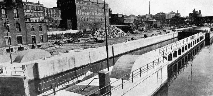
Siphon lock at Oswego. At the junction of Barge canal and Lake Ontario navigation. The only siphon lock in America and the largest lock to which the siphon principle has been applied.
Coming now to the second of the Long Island waterways, the Newtown Creek-Flushing Bay canal, we find a scheme which from time to time had been under consideration for more than a hundred years. Its purpose was to connect Newtown creek with Flushing bay by means of a channel cutting across the northwest corner of Long Island. The topography of the region is favorable, there being a creek valley on the west which extends inland to a central ridge, while on the east there is a similar stream valley and also a stretch of marsh land, both extending westerly to this dividing ridge, which is about three-quarters of a mile wide and from forty to fifty feet high and is composed of glacial drift.
The surveys of these possible routes determined a line by way of the marsh land which would run directly to Flushing bay, while by following the other easterly valley the line would intersect the route of the proposed Jamaica Bay-Flushing Bay canal and stop there, utilizing that waterway for further passage to Flushing bay. The latter route was the one chosen for estimate, since computations showed this to be the cheapest scheme and also the better in several other respects. But if this project had been considered as a separate enterprise and not in conjunction with the canal between Jamaica and Flushing bays, the marsh meadow route might have proved the more advantageous.
A sea-level canal was the only type considered for this project. Observations of tides showed that here too it was necessary to place a lock at each end of the waterway, but in this instance the lock planned for the north end of the Jamaica Bay-Flushing Bay canal would serve this canal also. The estimated cost, based on a channel and lock of Barge canal dimensions, was $5,894,144.
Advocates for the project claimed that it would increase wharfage space, induce commercial development of the district traversed, provide for sewage disposal and furnish a channel by which the dangerous navigation of Hell Gate and East river might be avoided. These advantages, like those of the other Long Island project, were chiefly of a local character. So the engineer pointed out in his report and he added that the probable commerce would not be large. If the proposed canal should be looked on as a Barge canal terminal and as such be considered a state-wide benefit, its cost for this purpose was excessive, since other near-by terminal sites, equally as good, were available and the saving in expense would be considerable.
The reports of the canal surveys of 1913 are contained in the annual report of the State Engineer for the same year, but in an abridged form they were transmitted to the Legislature as a special report on March 11, 1914. In the latter document State Engineer Bensel concludes with the following summary:
"A summary of cost of the five projects contained in the bill authorizing these surveys is as follows:
| Extension of Black River canal ............ | $19,000,000 |
| Reconstruction of Chemung canal (portion within New York state) ............ | 25,250,000 |
| Conversion of Glens Falls feeder into a canal ............ | 9,000,000 |
| Construction of canal between Flushing river and Jamaica bay ............ | 20,338,008 |
| Construction of canal from Newtown creek to junction with proposed canal Flushing and Jamaica bays ............ | 5,894,144 |
| --------------- | |
| $79,482,152 |
"It is to be noted that in this summary the portion of the Chemung canal lying in the state of Pennsylvania is not included. The estimate for this is $1,250,000.
"Also, the amount for the Jamaica Bay-Flushing Bay project is the estimate for the sea-level canal with a tunnel section. If the all open-cut type is desired, then $12,592,574 should be substituted. Both of these figures are based on the assumption that the Federal government will construct the northern portion of this canal, which is estimated to cost $618,468."
A few years later another attempt was made to add a branch to the State canal system. The Legislature of 1917 was induced to vote an appropriation for making a survey to extend the Barge canal to Auburn. The alignment of this proposed waterway, as set forth in the act, was to follow in general the outlet of Owasco lake between the city of Auburn and the village of Port Byron.
Auburn has never enjoyed the advantages of water transportation. In 1832 a private company was incorporated to connect it with the State system, but nothing ever came of this venture. The nearest point on the Erie canal was seven or eight miles away. In the early years, however, the city had the best of traffic facilities aside from water carriage. First, in the days of the stage coach, it was on one of the most important highways that crossed the state. Then, when the railroad came, following close to the highway, it still was on the most important artery of travel, the main line of the chief railway. But after the railroad straightened its course between Syracuse and Rochester, Auburn was side-tracked and was left on a minor branch. It is no wonder then that the people of this city, when a new avenue of commerce large with promise was coming so near to them, should want a branch of it to penetrate their borders.
Although the canal itself has not run through Auburn, the stream which flows through the city, the outlet of Owasco lake, has for many years been a feeder of the state waterway and the State has maintained a dam to make a canal reservoir of Owasco lake, which lies a few miles above the city. Some of the canal feeders have been made navigable, but this one never has. In effect, then, the scheme in question was to make this feeder navigable and to build it of sufficient size to allow the passage of such boats as should navigate the Barge canal.
Owasco outlet flows north in a fairly direct line from Owasco lake to Seneca river, passing through Auburn and Port Byron on its way. At the latter place it encountered the Erie canal, the old channel which has recently been superseded, and here its waters were diverted to feed that canal. At its mouth it now meets the new Erie, the Barge canal, which here lies in the bed of the canalized Seneca river. In the valley of this outlet lay the shortest and most natural route for a branch from the Barge canal to Auburn and under ordinary circumstances a survey for such a canal would have followed this stream to its mouth. The actual survey, however, after proceeding down the valley to Port Byron, turned sharply to the west and continued in that direction to the vicinity of Montezuma, where the line of the Barge canal was intersected. The reason for this was the crossing of two railroads, the West Shore and the New York Central, which a direct line would have necessitated. Such crossings would have been costly, much more costly than the short additional length required to reach the main line of the canal near Montezuma after it had itself crossed these railroads. Westerly from Port Byron the old canal alignment was followed for much of the way.
The proposed canal to Auburn was to be about twelve miles long and to have seven locks, five dams and from eight to ten bridges. The dams would have Taintor gate regulating sections and two of the locks were quite interesting in design -- built tandem and of thirty feet lift each, or an aggregate of sixty feet at one location. Barge canal dimensions were assumed for both channel and locks. Along the Owasco outlet seven power rights were encountered and damages for these had to be included in the estimate. Also there was an item of considerable amount for providing an ample water-supply, which was to be done by making Owasco lake, the only practical source of supply, capable of impounding more water. As Auburn depends on this lake for its water-supply, sufficient for both canal and city had to be provided. The estimated cost of the canal, including power rights, water-storage and all other items, was $9,240,000.
A certain fact, which is mentioned only in an incidental way in the report on the Auburn survey, becomes somewhat illuminating when we stop to consider it. Perhaps it will explain why this proposed canal and indeed why all of the recently projected additions to the State system have failed to pass beyond the stage of preliminary survey. The report states that in determining the amount of water needed for operating the prospective canal to Auburn it was assumed that 500,000 tons of freight would be moved in a season. Now let us see what it would cost the State to move these half million tons of freight. At four and a half per cent, the rate of interest then prevailing on new State bonds, the annual interest on the estimated cost of the canal would be $415,800. This would be eighty-three cents for each ton moved, or about seven cents per ton per mile, a sum at least ten times greater than the average rail rates before the war disturbed normal conditions, and nearly a hundred and forty times greater than the cost of transportation on the enlarged State canals as estimated by the committee which formulated the Barge canal policy in 1899. And thus far we have considered only interest on first cost, entirely neglecting weightier matters, such as repairs and operation and the sinking fund to liquidate the debt of construction. But we need not proceed; the partial calculation sufficiently illustrates our point.
During the legislative session of 1922 a somewhat feeble attempt was made to bring the authorization of this project to an issue. A bill carrying $8,800,000 was introduced in both the Assembly and the Senate but it was never reported from the committees to which it was referred.
The next proposition to review, while it contemplated an addition to the State canal system, differed widely from any of the proposed branches we have been considering. To be sure it looked toward the enlargement to Barge canal dimensions of the existing Erie canal between Tonawanda and Black Rock harbor, Buffalo, but its chief purpose was to provide at the western end of the Erie canal a channel both safe and suitable for boats plying on other parts of the Barge canal, should the route by way of the Niagara river -- the route to be used under Barge canal plans -- prove unsatisfactory. The Legislature of 1917 (by chapter 743) directed the State Engineer and the Superintendent of Public Works to investigate the two routes and after studying the situation to report on certain specified topics.
The whole question hinged on the ability of Barge canal craft to navigate against the current in Niagara river. Since this stream carries the accumulated waters of four of the Great Lakes and since Niagara falls is situated eleven miles below Tonawanda, there exists a current of considerable strength, which is increased in velocity whenever there is high water in Lake Erie or when heavy storms from the west pile up the waters at the eastern end of the lake and drive them into the river channel. If, in order to enable barges to stem this current, it should become necessary to place in them an over-installation of power, more than that required to propel them at desired speeds through other sections of the Barge canal, then the cost of operation would be correspondingly higher and as a consequence freight rates would be increased. This question, therefore, was one of prime importance to Barge canal traffic. The old canal between Tonawanda and Black Rock harbor, it should be remembered, although paralleling the river, was a wholly independent channel and free from current.
State Engineer Williams and Superintendent of Public Works Wotherspoon found little existing data on the subject of currents in the Niagara river and so they were obliged to have observations made especially for their use. These showed a maximum velocity of 2.76 miles per hour. In their report the officials stated that such a velocity did not produce an impassable current against which to tow. Power insufficient to propel a power boat with a reasonable number of consorts at a speed of at least six miles an hour, they considered, was also insufficient for economical operation on the Barge canal.
Since they did not consider the current in Niagara river prohibitive of successful Barge canal navigation, they reported against enlarging the old canal to Barge canal dimension and substituting it for the river route. They did recommend, however, that the State should retain and operate this portion of the old canal. It would serve for the passage of small boats and would also be available, should future experience prove its enlargement advisable.
The act authorizing this investigation of routes between Tonawanda and Buffalo required that an estimate be made of the cost of improving the old canal from Tonawanda to Black Rock harbor. In compliance with this request the State officials submitted estimates on six propositions. These were: (1) High-level line from Tonawanda to Black Rock, estimated to cost $6,252,507; (2) High-level line from Tonawanda to Black Rock (differing from No. 1 in wall construction), estimated at $6,121,798; (3) Low-level line from Tonawanda to Black Rock, estimated at $7,211,130; (4) High-level line from Black Rock to Rattlesnake island (Niagara river remainder of distance to Tonawanda), estimated at $3,195,675; (5) Low-level line from Black Rock to Rattlesnake island, estimated at $3,619,563; (6) High-level line from Tonawanda to Black Rock, channel eight feet deep, not widened, two Barge canal locks, estimated at $737,000.
_________________________
The State has not as yet deemed it advisable to construct any of the seven proposed additions for which surveys have been made. In our review of these investigations we have not had much to say about the merits of the several projects. That is not the especial province of the present volume; rather its scope is confined chiefly within the field of history. And in the case of these particular schemes we are more concerned in viewing them as evidences of a general waterway movement than in knowing the pros and cons of each individual project. But to understand the history of past events and also to permit former experiences to serve us in solving the problems of the present, we must learn why things happened as they did. So now, without presuming to criticise any of the proposed additions to the State waterway system, we would simply say that the investigations did not seem to carry conviction, either to those in authority in State affairs or to the people in general, that the projects were economically sound or the needs were so great as to warrant more than preliminary examination. In explanation of this attitude we may repeat what we have already said, that there appears to be abroad a better appreciation of the principle that waterways, to be worth constructing, must connect large industrial centers or tap some source of extended natural supply. There is also a lesser principle, the value of which has been proved by experience in New York state, which teaches that unfavorable topography so adds to the cost of both original construction and maintenance that a canal is inadvisable unless the need is great and the prospect of remunerative traffic sufficient to overcome this disadvantage. A glance at the profiles of some of our abandoned canals reveals the excessive elevations they had to overcome by means of manifold locks and suggests one reason why these waterways were deemed failures. This latter principle would seem to apply to some of the recently proposed additions.
http://www.eriecanal.org/Texts/Whitford/1921/chap19.html