HISTORY OF THE CANAL SYSTEM
OF THE STATE OF NEW YORK
TOGETHER WITH BRIEF HISTORIES OF THE CANALS
OF THE UNITED STATES AND CANADA
VOLUME I
BY NOBLE E. WHITFORD
CHAPTER I.
FIRST ATTEMPTS AT IMPROVEMENT.
From the time of the first settlements to the completion of operations by the Inland Lock Navigation Companies.
Henry Hudson sailed up the river that bears his name in 1609, and within a few years the first Dutch settlements on this river were planted. In the year preceding Hudson’s voyage, Samuel de Champlain had founded Quebec, and in 1615, while accompanying a hostile expedition of his allies, the Algonquins, he penetrated to the seat of the Iroquois power, and thus had the opportunity of discovering the Great Lakes, and of exploring the St. Lawrence river. The Iroquois sought an alliance with the Dutch to offset that of the Algonquins with the French, and in 1617 a formal treaty was made with the Amsterdam Company. As settlements were established on the Hudson and the Mohawk, by the Dutch, and on the St. Lawrence and the Great Lakes by the French, the natural watercourses between these two colonies became the routes of intercourse in times of peace, and the war-paths of the colonists and their Indian allies in times of hostility. Along these streams and at the carrying places were established the first forts. Consequently, the topographical features of the lands between these sections were well known while the country was still a vast wilderness.
In New York State there exist more favorable conditions for opening communication with the great inland lakes than elsewhere in the country. The westerly range of the Allegheny mountains disappears as it approaches the Mohawk valley, and the easterly range is cut by the Hudson, which affords a tidal navigation of about one hundred and fifty miles, while no other Atlantic river cuts this range or is navigable within many miles of the mountains. Recent geological investigation has deduced the fact that, during the recession to the northeast of the last glacial overflow, the waters of the lakes found an outlet through the ridge at Little Falls, and, until the further retreat of the ice-front opened the original channel down the St. Lawrence, the valleys of the Mohawk and Hudson formed the course of a swift, torrential stream. The low ridge at Rome thus became the divide between the St. Lawrence and Mohawk systems, the waters of the east continuing to flow down the Mohawk.
Although the early settlers knew not the causes of these phenomena, they soon saw the advantages of the topography. The first description we have of these natural avenues of communication is found in a report to the Colonial Governor, in 1724, by Cadwallader Colden, the Surveyor-General, afterwards elevated to the office of Lieutenant-Governor.
1 Colden appears to be one of the first to appreciate the value of the natural streams of New York as a means of commerce, in comparison with the French route by the St. Lawrence, and he even extends his view to a line of communication from the Hudson to the Great Lakes, and thence to the Mississippi and the ocean. He attributes the knowledge of the inland country to the energy of the French settlers, saying, "The French have been indefatigable in making Discoveries, and carrying on their Commerce with Nations, of whom the
English know nothing but what they see in the French Maps and Books. The Barrenness of the Soil, and the Coldness of the Climate of Canada, obliges the greatest number of the Inhabitants to seek their living by travelling among the Indians, or by trading with those that do travel." 2
He well appreciated the dangers of climate and storm that beset commerce on the St. Lawrence route. "These Difficulties are so considerable," he says, "that the French never attempt above one Voyage in a Year to Europe, or the West-Indies, tho’ it be really nearer Europe than any of the English colonies."
3
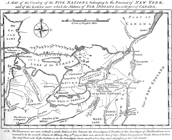
Reproduction of a map accompanying Colden’s History of the Five Indian Nations (London, 1747). The first edition of this book was published in New York in 1727, being the first work on New York history issued in the colony, and by its first printer (William Bradford).
Colden tells of the streams into the western country, and makes the first suggestion of the course of the interior route along which the Erie was finally built. "Goods are daily carried from this Province to the Sennekas," say the members of a committee, of whom Colden was one, in reporting to the Governor on November 6, 1724, "as well as to those Nations that lie nearer, by Water all the Way, except three Miles, (or in the dry Season, five Miles) where the Traders carry over Land between the Mohawks-River and the Wood Creek, which runs into, the Oneida-Lake, without going near either St. Lawrence-River or any of the Lakes upon which the French pass." 4 Again Colden says in his Memorial concerning the Furr-Trade: "But besides this Passage by the Lakes, there is a River which comes from the Country of the Sennekas, and falls into the Onondaga [Oneida and Oswego] River, by which we have an easy Carriage into that Country, without going near the Cataracui (Ontario) Lake. The Head of this River goes near to Lake Erie, and probably may give a very near Passage into that Lake, much more advantageous than the Way the French are obliged to take by the great Fall of Jaraga (Niagara).... But as this Passage depends upon a further Discovery, I shall say nothing more of it at this time." 5
In his "Memoir" prepared in honor of the celebration attending the completion of the New York canals in 1825, Cadwallader D. Colden reviews this report of his grandfather in the following interesting passages, which reveal the routes of intercourse at the time:
"In seventeen hundred and twenty-four, the then surveyor general of the Province of New York, made a report to the Colonial Governor, in which he describes the water courses and carrying places between Albany and Montreal, by way of Lake Champlain, and between Albany and the Cataraqui Lake, which is now called Ontario, by the Mohawk River, and the river which runs into the Oneida Lake, with as much accuracy as they could be described at this moment. The carrying place between the Mohawk, and the stream which we now call Wood Creek, he describes as a ‘portage only three miles long, except,’ says he ‘in very dry weather when the goods must be carried two miles further.’ He then describes the passage down the Onondaga River, to the Cataraqui Lake and shows that goods might be carried from Albany to that Lake by the Mohawk, the Oneida, and the Onondaga River, cheaper, and much more conveniently, than as they were then transported, to the mouth of the Oswego river by way of the Hudson, Lake Champlain, Montreal, and River Saint Lawrence." 6
"The historian of the Five Indian Nations informs us, that Governor Burnet erected a Fort and trading houses at the mouth of the Onondaga River, on account, says he, ‘of its water communications with the country of the Iroquois, and for the facility of transportation between the Lakes and Schenectady, there being but three portages in the whole route, and two of them very short.’ These, no doubt, were the carrying places, at the Little Falls, the Wood Creek, and at the Oswego Rapids." 7
Of this same report of the Surveyor-General in 1724, the committee of the corporation of the City of New York, having charge of the celebration at the opening of the Erie canal, says:
"In this Report the author not only describes the water-courses and portages between this and Canada, and those between us and the great western Lakes, with wonderful accuracy, but presents, in the clearest manner, the immense facilities which these water communications are susceptible of affording to our internal trade. He also carries his views beyond the Lakes to the Mississippi, and after stating that ‘many of the branches of that river come so near to the branches of the rivers which empty themselves into the Great Lakes, that in several places there is but a short land carriage from the one to the other;’ he concludes with the following emphatic observation: -- ‘If one considers the length of this river (the Mississippi) and its numerous branches, he must say, that by means of this river and Lakes, there is opened to his view such a scene of inland navigation as can not be paralleled in any other part of the world.’" 8
"The French government of Canada very early attempted to prevent our participation in the Indian trade, by their establishments on Lake Ontario, at Fort Frontinac in the year 1672, and at Fort Niagara in the year 1725, and on Lake Champlain by their Fort St. Frederick, built near Crown Point, in the year 1731." 9
Thus these natural watercourses became the first public highways, and roads, when they were opened later, were so poor and the carrying of goods over them so expensive, that the people naturally retained the streams as channels for the transportation of goods and often as a means of travel, making some improvements from time to time, as we learn from some of the early writers.
Carver, who traversed this territory in seventeen hundred and sixty-eight, says, "The Oniada Lake, situated near the head of the River Oswego, receives the waters of Wood-Creek, which takes its rise not far from the Mohawks River. These two lie so adjacent to each other that a junction is effected by sluices at Fort Stanwix." 10
"Here [Little Falls] the roaring rapids interrupted all navigation, empty boats not even being able to pass over them. The early portage of one mile here in sleds over the swampy ground has been described as it was in 1756, when enterprising Teutons residing here transferred all boats in sleds over marshy ground which would ‘admit of no wheel carriage’ ... later on, about 1790, we find that the Germans’ sleds were out of use and that boats were transferred on wheeled vehicles appropriately fashioned to carry them without damage to their hulls. No great boats could be transferred by such means; this fact had a tendency to limit the carrying capacity of Mohawk batteaus to about one and a half tons." 11
Christopher Colles, who was authorized by the Legislature, in 1785, to make the first survey of the Mohawk, says that "before the war 600 batteaux passed annually between the Wood Creek and the Mohawk River." 12
The war of 1756, and especially the two expeditions under Colonel Bradstreet and General Prideaux, which used the route of the Mohawk, Wood creek and Oneida lake for transporting troops and military stores, demonstrated the necessity of improved inland navigation. Governor George Clinton was a subaltern officer in this war, having been engaged in the operations against Fort Frontenac (Kingston) and Niagara, and doubtless the knowledge he gained of the natural waterways at that time induced him in 1791 to recommend to the consideration of the Legislature the subject of their improvement. After the treaty of Paris in 1763, till the Revolutionary war in 1775, the channel of communication to Oswego was in constant use by the fur traders. From the first the populous and powerful Indian confederacy of the Six Nations, distributed along the shores of the Genesee river, the Canandaigua, Seneca, Cayuga and other small lakes in the central and western part of the colony, had been the ally of the English against the hostile French, and the easy passage to their country through the Seneca river had long been used by those who carried on a valuable trade with these tribes.
During the latter half of the eighteenth century England had vigorously engaged in the building of canals. The invention of canal-locks had given a great impetus to the construction of canals in continental European countries, but the English people had been slow to follow their example, delaying nearly a century after the famous Languedoc canal, designed by Riquet, had been built between the Bay of Biscay and the Mediterranean. The master minds of the new colonies were quick to perceive the vast field for inland navigation in America, and almost at its beginning, the young Republic followed the lead of the mother country in these public improvements.
In the colonial period, the restrictive measures imposed by England were not conducive to public improvements, and no effectual steps were taken. However, the first official mention of improving inland navigation occurred during that period, as it appears in the following message from Governor Moore to the General Assembly, on December 16, 1768: --
"A message from his Excellency the Governor, by Mr. Banyar, Deputy Secretary, which being read, is in the words following, viz.
"Gentlemen,
" 'While the attention of the house of Assembly is employed in forming new regulations for the Indian trade, it may not be thought improper to lay before them any proposal which can give assistance to the operation of their plans, and by removing the difficulties which particularly affect that branch of commerce, enlarge the advantages proposed to the province.
" 'It has been observed, by all who are concerned in the Indian trade, that the great inconvenience and delay, together with the expense attending the transport of goods, at the carrying places, have considerably diminished the profits of the trader, and called for the aid of the legislature, which, if not timely exerted in their behalf, the commerce with the interior part of the country may be diverted into such channels as to deprive this colony of every advantage which could arise from it. The obstruction of the navigation of the Mohawk river, between Schenectady and Fort Stanwix, occasioned by the falls of Canajoharie, has been constantly complained of, though it is obvious to all who have been conversant in matters of this kind, that the difficulty is easily to be removed, by sluices, upon the plan of those on the great canal of Languedoc, in France, which was made to open a communication between the Atlantic ocean and the Mediterranean. The opportunity I had in my tour, last summer, of examining this carrying place, and of measuring the falls, has engaged me to recommend to the house of Assembly, the improvement of our inland navigation, as a matter of the greatest consequence to the province, and worthy of their serious consideration.'
"Ordered.
"That the said message be referred to the consideration of the committee to whom his Excellency's message of the 6th is committed.
"The house, according to order, resolve itself into a committee of the whole house, to consider of, and draw up proper and constitutional resolves, asserting the rights of his Majesty's subjects within this colony, which they conceive have been greatly abridged and infringed by several acts passed by the last parliament of Great Britain." 13
After long discussions these resolves passed the House on December 31, and on the second of the following month the Governor exercised his prerogative by dissolving the Assembly, thus leaving the proposition for inland navigation not acted upon. Here the project rested till after the close of the Revolutionary war.
To George Washington is due the honor of being the projector of canals in the United States. In the fourth edition of Phillip's General History of Inland Navigation, published in London in 1803, we read:
"The immortal Washington was the original father and promoter of these canals and improvements, and well did he deserve that admirable motto, -- 'Twice the savior of his country. After conducting her to liberty, he opened her the way to prosperity by new roads and canals, and varying the produce of agriculture.' " 14
Early in his life General Washington had given his attention to measures for facilitating the means of intercourse between the eastern and western territories. Before the Revolutionary war he had succeeded so far as to obtain official sanction for one of his projected plans -- a bill empowering individuals to open a part of the Potomac for navigation -- and the enterprise was in a fair way to successful execution, when the war directed the energies of the whole country to the struggle for independence.
Before peace was declared, Washington started from Newburgh on a journey through northern and central New York. In a letter to the Marquis de Chastellux he wrote thus in 1783: "I have lately made a tour, ... through the Lakes George and Champlain as far as Crown Point; then returning to Schenectady, I proceeded up the Mohawk river to fort Schuyler, crossed over to Wood creek which empties into the Oneida lake, and affords the water communication with Ontario. I then traversed the country to the head of the eastern branch of the Susquehanna, and viewed the lake Otsego, and the portage between that lake and the Mohawk river at Conajohario. Prompted by these actual observations, I could not help taking a more contemplative and extensive view of the vast inland navigation of these United States, and could not but be struck with the immense diffusion and importance of it; and with the goodness of that Providence which has dealt his favors to us with so profuse a hand. Would to God we may have wisdom enough to improve them. I shall not rest contented until I have explored the western country, and traversed those lines (or great part of them) which have given bounds to a new empire." 15
In 1784 we find the first official mention of improvements after the Revolutionary war. A petition from Christopher Colles appears in the Assembly Journal of November 3, 1784, and in the Senate Journal of November 8, 1784, proposing a plan of inland navigation on the Mohawk river. On the 6th of November, Mr. Adgate, from the Assembly committee to whom was referred the memorial of Christopher Colles, reported: "That it is the opinion of the Committee, that the laudable proposals of Mr. Colles, for removing the obstructions in the Mohawk river, so that boats of burthen may pass the same, merit encouragement; but that it would be inexpedient for the legislature to cause that business to be undertaken at the public expense.
"That as the performing such a work will be very expensive, it is therefore the opinion of the Committee, that if Mr. Colles, with a number of adventurers (as by him proposed) should undertake it, they ought to be encouraged by a law, giving and securing unto them, their heirs and assigns forever, the profits that may arise by the transportation, under such restrictions and regulations as shall appear to the Legislature necessary for that purpose; and authorizing them to execute that work through any lands or improvements, on payment of the damages to the proprietors, as the same shall be assessed by a jury," and it was "Resolved, That the House do concur with the Committee in the said report." 16
Colles was an Irish engineer, who emigrated to America in 1765. Previous to the Revolutionary war he had delivered a series of lectures on inland lock navigation, and had proposed to build a reservoir for New York City. He was a man possessing large knowledge and ingenuity, but his scheme was considered visionary and he was always in pecuniary straits.
The subsequent endeavors of Colles are well described in the following selections from The Canal Policy:
"At the next meeting of the legislature, Mr. Colles again presented a memorial, and on the 5th of April, 1785, a favorable report was made by the committee to whom it was referred: and $125 was appropriated in the supply bill 'for the purpose of enabling to him to make an essay towards removing certain obstructions in the Mohawk river, and to exhibit a plan thereof to the legislature at their next meeting.'
"In pursuance of this arrangement, Mr. Colles visited the country to be affected by the intended improvements, and took an actual survey of the principal obstructions upon the Mohawk river as far as Wood creek. The results of this journey of observation and survey, were published by him in a pamphlet, entitled 'Proposals for the speedy settlement of the waste and unappropriated lands on the western frontier of the state of New York and for the improvement of the inland navigation between Albany and Oswego. Printed at New-York, by Samuel Loudon, 1785.'
"In this pamphlet he proposed the establishment of a company with a capital of Ł13,000 to prosecute the works, and to be allowed toll -- and also to receive a grant of 250,000 acres of western lands, on condition of completing the inland navigation of the Cahoes, the Little Falls, and Fort Schuyler, within five years.
| "He estimated the expense of a canal of four and half miles, twenty locks &c. at [the Cahoes] |
Ł6,000. |
| At the Little Falls, one mile of canal, six locks &c.
|
3,000. |
| At Fort Schuyler, (now Rome) 1 mile and a fourth, two
locks, &c. |
2,000. |
| Improving some of the rifts. |
2,000. |
| |
-------- |
| |
Ł13,000. |
| |
======== |
"And he stated, as the least revenue to the company that could accrue, an annual income of Ł936, arising from the passage of only 120 tons of goods weekly, at six shillings per cwt. for twenty-six weeks.
"At the next session Mr. Colles renewed his application, and on the 8th of March, 1786, a committee reported favourably on a memorial of Christopher Colles and his associates, and leave was given to bring in a bill to compensate them for the purposes specified in that memorial.
"It does not appear that any further steps were taken on the part of Mr. Colles. His operations probably failed for the want of subscribers to the contemplated association. It is not a little remarkable that this project commenced so soon after the termination of the Revolutionary war, and that contemporaneous efforts were made in some of the southern states."
17
The Assembly Journal of 1786 shows that on the first of February, "A petition from Christopher Colles, with a report of the practicability of rendering the Mohawk River navigable, was read and referred to Mr. Jeffrey Smith," and others. The following is an extract from the Journal of March 17, 1786:
"Mr. Jeffrey Smith moved for leave to bring in a bill, entitled, "An act for improving the navigation of the Mohawk river, Wood creek and the Onondaga river with a view of opening an inland navigation to Oswego and for extending the same, if practicable, to Lake Erie.
"Ordered, That leave be given accordingly.
"Mr. Jeffrey Smith accordingly brought in the said bill, which was read the first time, and ordered a second reading."
The language of this bill is significant as it is the first time that Lake Erie is mentioned in connection with inland navigation, and not again does it appear in legislative action (except the bills of 1797 and 1798 for incorporating the Niagara Canal Company to construct a canal around the falls from Lake Erie to Lake Ontario) till the resolution of 1808 ordered the survey of the route which later became the Erie canal.
Although this bill, introduced by Mr. Jeffrey Smith, was reported by the committee of the whole, on the twenty-fifth and twenty-ninth of March, and the fourth and fifth of April, the session closed without any final action being taken.
We find no further record of official action till the year 1791, but meantime other states were adopting measures to improve their inland navigation. At this time it is appropriate to mention a man, who, on account of knowledge gained through his travels during these years, was able to influence subsequent legislation, -- Mr. Elkanah Watson, a native of' Massachusetts, but residing in Albany for many years after 1789. Having traveled extensively in both the United States and Europe, he had become conversant with many enterprises for improving navigation. He became a director of the Inland Lock Navigation Company when that company was incorporated in 1792.
While not the first to propose the improvement of the natural waterways of the state, he is still entitled to lasting praise for his earnest endeavors toward bringing this scheme to fruition. In 1820 he published in Albany a book entitled History of the Rise, Progress, and existing Condition of the Western Canals of the State of New-York, from September 1788, to the completion of the Middle Section of the Grand Canal in 1819. Unhappily the chief object of writing this book was to support the claim of his friends, in a controversy which arose as the Erie canal was nearing a successful completion, that he should have the exclusive honor of being considered the projector of the canal policy of the State. A few excerpts from this book will give a good idea of the conditions that prevailed in New York, and of the progress of canal projects in other states. He says:
"In the winter of 1785, I spent two days with the immortal Washington, at Mount Vernon. His mind being intently settled on the project of connecting the western waters, by canals, with his favorite Potomack, and of improving the navigation of the Monongahela, and other branches of the Ohio; principally with a view, of diverting the fur trade from Detroit to Alexandria, instead of going to Montreal, as heretofore. 18 His conversation was principally turned to the interior country, and opening the navigation of the Potowmack, by locks and canals, -- at the Seneca, great and little falls. His mind appeared absorbed, and devoted, to this great object, now in earnest contemplation." 19
He quotes as follows from notes made at the time of his visit: -- "Both Virginia and Maryland have reciprocally incorporated a canal company, of which Washington had accepted the presidency. Preparations are now in full train to commence operations the ensuing spring; not only to open a free navigation of the Potowmac, but eventually to remove obstructions In such branches of the Ohio as point towards Lake Erie; so as not only to give a direction to the fur trade from Detroit to Alexandria, but also the produce of those vast intervening countries which lie as yet in a state of nature. To demonstrate the practicability of this, and the policy of preserving a commercial intercourse with those extended regions, especially should the Mississippi be opened, was his constant and favorite theme.
"To establish, also, the probability that the fur trade from Detroit will take this direction, he produced to me the following estimate, which I copied from his MS. in his presence, and with his aid.
" "'From Detroit, at the head of Lake Erie, via Fort
Pitt, (now Pittsburgh) and Fort
Cumberland, at the head of the Potowmac is, |
607 miles. |
| |
'To Richmond, |
840 |
| |
'To Philadelphia |
741 |
| |
'To Albany |
943 |
| |
'To Montreal, |
955.' |
"Thus it appears that Alexandria is 348 miles nearer Detroit than Montreal, with only two carrying places, of about forty miles." 20 NOTE:
The three years following his visit to General Washington, Mr. Watson spent in traveling about the southern States, visiting the sites of various projected canals. In 1788 he returned north, and in September of that year was traveling in the valley of the Mohawk, being present at the Indian treaty at Fort Stanwix (Rome). Speaking of this journey he says: "It was on this occasion I first conceived the idea of the practicability of counteracting, at least by a fair competition the favorite plan Washington was then pursuing with zeal and ardour, to allure all the trade of the western regions, connected with the Ohio and the great lakes, -- even the fur trade from Detroit, to Alexandria. 21 Doubtless many others may have conceived the same project many years prior, and probably subsequent, to my first visit at Fort Stanwix, in 1788. ... But I have not yet been able to trace anything like a settled plan or system, to combine these waters prior to 1788." 22
The condition of the country at this time may be imagined from the following extract from Mr. Watson's Journal, describing his journey on horseback in 1788, while in the vicinity of Fort Schuyler (Utica): "From Col. Starling's, I began to traverse the deserts, bordering on the Indian country. The road is almost impassable, as I was upwards of three hours reaching the Mohawk, opposite old Fort Schuyler, only six miles. Here I reluctantly forded the river, being alone, without a guide, and both shores alive with savages." 23
In his speech to the Legislature on January 5, 1791, Governor George Clinton said:
"Our frontier settlements, freed from apprehensions of danger, are rapidly encreasing and must soon yield extensive resources for profitable commerce; this consideration forcibly recommends the policy of continuing to facilitate the means of communication with them, as well to strengthen the bands of society, as to prevent the produce of those fertile districts from being diverted to other markets." 24
On February 15, 1791, Mr. Williams proposed in the Senate a concurrent resolution to appoint a joint committee "to examine what new roads are necessary to be opened in this state, and what obstructions in the Hudson and Mohawk rivers will be proper to be removed, and to report thereon with their opinion of the most eligible mode for effecting the same, and defraying the expense thereof." This resolution being carried, nine to eight, and being agreed to by the Assembly, the committee was appointed and on the twenty-sixth of the same month, the report was made to the Assembly by James Livingston of Montgomery county, as appears from the following excerpt from the Journal of that body:
"Mr. Livingston, from the committee of this House, consisting of a member from each county in the state, appointed of a joint committee with a committee of the honorable the Senate, to examine and report relative to roads and inland navigation, reported, that it is the opinion of the committee, that the commissioners of the land office be authorized to make and offer proposals to such persons or association of persons as will contract to open a water communication between the Mohawk river and Wood-Creek; and such person or persons as will remove impediments to the navigation of boats between Rensselaerwyck and Fort Edward; and such person or persons as will open a water communication between Fort Edward and Lake Champlain; with power to grant such person or persons an exclusive right to the profits of a reasonable toll on the canals when so opened, for a limited term of years -- And further, that it is the opinion of the committee, that the rivers Delaware and Susquehannah with their navigable branches ought, to be made public highways; and that provision by law ought to be made for removing and preventing any obstructions that now are, or here after shall be made in the free navigation thereof. And that the committee are further of opinion, that the commissioners of the land office be requested to report to this House what new roads are proper to be laid out at this time, and whether any and what legislative provision is necessary for that purpose.
"Ordered, that the report be committed to a committee of the whole House." 25
As a result of this favorable report, the first canal law in New York State was passed March 24, 1791, entitled " An act concerning roads and inland navigation." This act contained the following clause: "And to be it further enacted ... That the commissioners of the land office be and they hereby are authorized to cause to be explored, and the necessary survey made, of the ground situated between the Mohawk river, at or near Fort Stanwix, and the Wood creek, in the county of Herkimer and also between the Hudson river and the Wood creek in the county of Washington; and to cause an estimate to be made of the probable expense that will attend the making canals, sufficient for loaded boats to pass; and report the same to the Legislature at their next meeting." Ł100 was appropriated for the expenses of this exploration.
During the recess of the Legislature, these surveys and estimates were made. In September, 1791, Major Abraham Hardenburgh, assisted by Benjamin Wright, who was later very intimately connected with the building of the canals of the State, made the necessary surveys between the Mohawk river and Wood creek. The line as laid out was very nearly that on which the canal was afterwards built. The whole expense of the surveys was only three-fifths of the amount appropriated. 26
Before considering the report of these investigations, it will be interesting to notice another journey taken by Elkanah Watson, which had considerable bearing on the subsequent action of Legislature.
For the purpose of obtaining information for business operations as well as to learn the possibilities of opening the streams for navigation, Mr. Watson made a journey from Albany to Seneca lake, chiefly by water, in September, 1791, in company with Gen. Van Cortland, Stephen N. Bayard and Jeremiah Van Rensselaer. His Journal of this journey contains many references to the canals, which he saw in imagination. In speaking of the manufacture of salt near Salt (now Onondaga) lake, he makes these significant entries:
"These works are in a rude, unfinished state, -- but are capable of making about eight thousand bushels of salt per annum; which is nearly the quantity required for the present consumption of the country. ...
"Providence has happily placed this great source of comfort, and wealth, precisely in a position accessible by water and every direction.
"When the mighty canals shall be formed and locks erected, it will add vastly to the facility of an extended diffusion, and the increase of intrinsic worth.
"It will enter Ontario, and the other great lakes, and find its way down the St. Lawrence, by Oswego; -- into Pennsylvania, and the Chesapeake, up Seneca river, to the head of the Seneca lake, and by a portage, (perhaps eventually a canal,) of eighteen miles, to Newtown, on the Susquehanna river: -- And through the canals in contemplation, up Wood creek, and down the Mohawk river into the Hudson." 27
Of the difficulties encountered on these natural watercourses, he says: "At that period [1791] they could only transport from one and a half, to two tons, in a flat boat, at an expense from seventy-five to one hundred dollars a ton, from Schenectady to this place (Seneca Falls)." 28
After his return, Mr. Watson put into the hands of General Philip Schuyler, a prominent member of the Senate, on January 1, 1792, a report formed from the remarks and estimates contained in his Journal, in which he traced the route of the proposed canals, described the obstacles to be removed, devised the mode of removal, calculated the probable expense of some of the operation, and concluded with the declaration, that "it would require a folio volume to point out the advantages that would result to the union, to the state, and to individuals, from laying the navigation completely open." 29 About the same time he gave his Journal to General Schuyler for perusal. After reading these, General Schuyler declared his intention of doing his utmost to obtain a canal law that winter.
On January 3, 1792, the commissioners of the land office submitted their report of surveys made in pursuance of the act of March 24, 1791. A part of the report reads thus: "The commissioners are happy to find that these objects are not only practicable, but attainable at a very moderate expense, when put in competition with their advantages and importance to the state."
Two days later Governor George Clinton, in a speech conveying this report to the Legislature, says: "I now submit to you their report, which ascertains the practicability of effecting this object at a very moderate expence; and I trust, that a measure so interesting to the community, will continue to command the attention due to its importance, and especially as the resources of the state will prove adequate to these and other useful improvements, without the aid of taxes." 30
This report was referred to a joint committee of both houses, and on February 7, General Williams of the Senate brought in a bill entitled "An act for constructing and opening a canal and lock navigation in the northern and western part of this state." This bill met with opposition from friends of the project, on the ground that its scope was too limited. General Schuyler then came to the front as the chief advocate, and later, during the years of construction, he acted as president of the companies undertaking the work, and also as superintending engineer during the early stages. From the correspondence of General Schuyler at this time, we discover some of the causes which influenced legislative action. The following is an extract from a letter to General Schuyler written by Elkanah Watson in February, 1792: "I have been attentive to the progress of the great object of the Western Canals since the commencement of the session of the Legislature. I observe, with great regret, that no one of that body (not even the Governor) appears to soar beyond Fort Stanwix except yourself. To stop at that point will be half doing the business. ... The charter should stretch to the Seneca Lake, and to the harbor of Oswego, as suggested in my journals ... so as to admit the commerce of the great lakes into Hudson river." 31
In replying to this letter on March 4, General Schuyler says: "A joint committee of both houses (of which committee I was not one) had been formed: this reported a bill for incorporating two companies, one for the western, and another for the northern navigation. The former was to have been carried no farther than the Oneida lake. The bill contemplated a commencement of the works from the navigable waters of the Hudson, and to be thence continued to the point I have mentioned, and it obliged the corporation, in a given number of years, (which was intended to be ten) to the completion of the whole western navigation. When this bill was introduced into the senate, the plan generally appeared to me so exceptionable, that I thought it incumbent on me to state my ideas on the subject at large. They were approved of unanimously by the committee of the whole house, and I was requested to draught a new bill. This was done, and it has met with the approbation of the committee of the whole, and will be completed tomorrow by filling up the blanks. ... A clause was proposed for preventing any canals to the Susquehannah, but it was lost: it being conceived improper to oblige the inhabitants of the western country to make Hudson's river, or the commercial towns on it, the only markets." 32
The Legislature had met in New York, early in January, and so zealous was Mr. Watson for the success of the project, that he had gone there to aid General Schuyler, staying several weeks, and proposing to go again if needed. While in New York he had addressed an article to the Legislature over the signature of "A Citizen," and after returning to Albany another over the signature of "An Inland Navigator." These were published in The New York Journal and Patriotic Register, and in them he set forth the natural advantages possessed by New York State for opening navigation to the western country, and the efforts being made by other States for obtaining the western trade, and advocated the larger policy of extending the rights of the company to the Great Lakes. He says in one of the articles: "Hence it appears that every natural advantage is in favor of New York: provided only attention is paid to promote the improvements necessary; and it merits a serious consideration, that although nature has favored this quarter, yet, through inattention, the channel of commerce may receive an early bias to a different point: and commerce is of such a nature, that when once established in any particular direction, it is generally found difficult to divert it." 33
Through the influence of General Schuyler the bill as drawn by him passed both Houses on March 24 and the council of revision on March 30, 1792. This law, entitled "An act for establishing and opening lock navigations within this State," incorporated two companies, -- the Western and the Northern Inland Lock Navigation Companies, and declared the purpose of the Western Company as that "of opening a lock navigation from the now navigable part of Hudson's river to be extended to Lake Ontario, and to the Seneca lake," and the other company "for the like purpose, from the now navigable part of Hudson's river to Lake Champlain." The canals were to be of a size for the passage of boats forty feet long, twenty feet wide, and drawing, when loaded, two feet of water. The act provided for the opening of books for taking subscriptions, no person to be allowed to subscribe for more than ten shares, and the sum of twenty-five dollars per share to be paid at the time of subscribing. The number of shares was limited to one thousand, but as the work progressed, more money could be raised by assessing the old subscribers, or obtaining new ones. The act further provided for the gift by the State, of twelve thousand five hundred dollars to each company, after it had expended twenty-five thousand dollars, and it limited the rate of toll to twenty-five dollars per ton from the Hudson to Seneca lake or Lake Ontario, and to twenty dollars per ton from the Hudson to Lake Champlain.
So great did the task appear that the companies were granted fifteen years in which to accomplish the work. As the necessity arose, laws were passed by succeeding Legislatures, amending this act of incorporation, and giving the companies more privileges, and even State aid.
According to the act of incorporation, the books for subscriptions were to be opened at New York and Albany on the first Tuesday of May, 1792, and to remain open till the last Tuesday of the same month. Mr. Watson tells us that he had the good fortune to be in New York when the books were opened. In describing the event, he says: "They had been opened three days by the commissioners, at the old coffee-house, and not a share was subscribed. I considered the cause hopeless, -- called on my friend (I think it was) James Watson, Esq., and induced him, with much persuasion, to subscribe twenty shares; from that moment the subscriptions went on briskly.
"On my arrival in Albany, the commissioners in that city had kept the books open several days, at Lewis's old tavern, in State-street, and no mortal had yet signed to exceed two shares. I immediately subscribed seven in each company, and wrote to Gen. Schuyler, then in New-York, soliciting him to authorize me to extend his subscriptions as an example to others.
"From the moment I subscribed ten shares for Gen. Schuyler, by his directions, the subscriptions in Albany also progressed rapidly." 34
In the summer and fall of 1792, surveys were made along both the western and northern routes. A report of the survey along the Mohawk river is contained in the following quotation from Mr. Watson's history:
"The following is a summary of an official report, made to the directors of the Western Inland Lock Navigation Company.
" 'The committee appointed on the 14th August, 1792, &c. beg leave to report, &c.
" 'That they proceeded, on the 20th August last, from Schenectady, by water, accompanied by surveyors and artificers, to Fort Stanwix, 121 3-4 miles, as the river runs.
" 'That they measured the depth of the Mohawk, in its whole extent from Schenectady.
" 'That they noticed all the obstructions on the route, estimating the probable cost of a canal and locks, at the Little Falls, three-fourths of a mile in length, and thirty-nine feet fall; -- that the whole, with five locks, will cost about Ł10,500.
" 'That a canal at Fort Stanwix, and improvements in Wood creek, will cost about Ł3,000.
" 'That means be adopted to extend the navigation into Ontario, from the Hudson's river. That the aggregate estimated expense to complete the navigation, from Schenectady to Wood creek, is Ł39,500, &c. All which is respectfully submitted. Albany, 1st September, 1792.
Philip Schuyler
Goldsbrow Banyer
Elkanah Watson |
} |
Committee.'"35 |
The surveys were considered with favor by the directors of the companies, and it was determined to begin operations at Little Falls. However, before work was begun, the Legislature was appealed to for a modification of the law, which incorporated the company. On December 22, 1792, an act was passed which specified that the width of locks could be determined by the officers of the companies, but the locks must not be less than ten feet wide by seventy feet long; also that the previous act requiring two feet depth should not be strictly enforced in this depth was maintained for the greater part of the time from March to December; and that the companies could use surplus waters for various manufacturing and irrigating purposes. The granting of this privilege inaugurated a policy which proved very disastrous to the interests of the State in after years. While the waterways were under the control of corporations there was not much abuse of this privilege, but later when the State had completed the Erie canal, and had made similar concessions, so much water was taken that navigation was seriously impeded and large sums of money were expended to supply sufficient water for both canal and manufacturing purposes. This subject will be more fully discussed, at the proper time.
During the following spring, work was begun at Little Falls. To quote the language of the directors: "The work was accordingly commenced in April 1793, with nearly three hundred laborers, besides a competent number of artificers, but its progress was arrested early in September, for want of funds, many of the stockholders having neglected to pay the requisition made by the Directors, either because they had not the means to supply such advances, or from an apprehension of the impracticability of succeeding in the operation. -- January, 1794, the work was, however, recommenced, although feebly, and some progress made, in hopes that the Legislature would afford aid, by grants; or loans of money, or by taking the unsubscribed shares. Accordingly, the Legislature ... directed a subscription, on the part of the people of the State, of two hundred shares to each company; this measure was attended with the most salutary effects. The hopes and confidence of the companies were revived and the work recommenced in May last, with a correspondent degree of alacrity; ... it was the 17th of November before the Canal and Locks were so far completed, as to afford a passage to boats." 36
Describing the canal, they say: " ... its length is 4752 feet, ... the aggregate fall is 44 feet 7 inches. Five locks having each nearly 9 feet lift are placed towards the lower end of the Canal, and the pits, in which they are placed, have been excavated out of solid rock, of the hardest kind; the chamber of each lock is an area of 74 feet by 12 feet in the cleave, and boats drawing three feet and an half of water may enter at all times; the depth of water in all the extent of the Canal beyond the locks is various, but not less than 3 feet in any place; near the upper end of the Canal a guard lock is placed without lift, to prevent a redundancy of water; ... about 2550 feet of the Canal is cut through solid rock." 37
In the summer of 1793, Wood creek, the stream which flows into Oneida lake, was cleared of fallen timber and straightened to the extent of shortening its length more than seven miles.
In 1793, the Northern Company began a canal near Stillwater intending to extend it to Waterford, but work was stopped for lack of funds. A contract was also made for constructing a canal to open the navigation of the northern Wood creek with Lake Champlain, and In 1794 this creek was partially cleared of fallen timber.
Previous to 1795, the directors had proceeded without the services of an engineer, but in May of that year they employed Mr. William Weston, an able English engineer, to superintend the work at Little Falls, and to examine the whole line of proposed improvements. His report and estimates accompanied the report of the directors to the Legislature, he estimated the cost of providing navigation from the western extremity of Cayuga lake to the Hudson river at Troy, for "boats of twenty tons, and upwards," at Ł189,497, the total length being three hundred and two miles. This did not include the work at Little Falls, which had been completed. An alternate route to join the Hudson at Waterford was estimated at Ł192,769, with a distance of 299 miles.
The aid from the State, to which the directors referred in their report, was granted on March 31, 1795, when the Legislature passed an act directing the State Treasurer to subscribe two hundred shares to the stock of each company. This was in answer to a petition from the directors representing that only seven hundred and forty-three shares had been subscribed to the Western Company, and six hundred and seventy-six to the Northern Company, and of these about two hundred and forty in each company had been forfeited by reason of the subscribers not paying the required amounts.
It was becoming evident that the proposed improvements were too onerous for the companies to prosecute unaided, and the Legislature, from time to time, granted appropriations and loans. An act of April 1, 1796, offered aid in extending the improvements down the Hudson to Albany. This act provided that the directors of the Northern Company should employ an able engineer to examine the river from Albany to the mouth of a creek north of Troy, called Meadow creek, to determine the practicability of improving the channel so as to obtain navigation for boats of six feet draught, and to estimate the cost of this work. If the cost did not exceed four thousand pounds, and if one thousand pounds were raised by voluntary contribution, then the State Treasurer was authorized to pay to the company three thousand pounds. The act further provided for the payment of fifteen hundred pounds for improving the river from Meadow creek to Mill creek, the point where the Northern Company was to begin operations, if the engineer's estimate of cost did not exceed two thousand pounds and provided that five hundred pounds were raised by contribution.
By the act of April 11, 1796, the State loaned fifteen thousand pounds (thirty-seven thousand five hundred dollars) to the Western Company, taking a mortgage on the canal and locks at Little Falls.
By the act of March 17, 1797, the sum of three thousand pounds was appropriated for the work of improving the Hudson to Albany, contemplated by the act of April 1, 1796. William Weston, the engineer employed to prepare the plans, estimated that the cost would exceed four thousand pounds, but the Legislature appropriated the amount promised by the former act, upon condition that the deficiency be raised by contribution. The act further specified that the work should be done according to the plans of the engineer, which called for a double row of piles with side stringers and ties, and stone filling. In after years various schemes were tried, but finally a plan similar to this first method has been adopted as best, -- to confine the river between parallel dykes, so that the current will keep the channel open.
On March 17, 1797, was passed another act which provided for the borrowing of two hundred and fifty thousand dollars by the Western Company.
As funds were provided, work was carried on at various places, so that navigation was considerably bettered, but the expectations of the projectors were never fully realized and it is even doubtful whether the improvements proved to be of much lasting benefit. In the following quotations from two writers of the time (Elkanah Watson and De Witt Clinton), two views of the success of the enterprise are presented. Mr. Watson, it must be remembered, was one of the directors of the company, and was intimately connected with the inception and projection of the scheme, while to De Witt Clinton's energy was largely due the successful completion of the Erie canal, but it must be remembered also that Clinton's writings -- particularly this one -- evince a tendency to belittle the whole early project, that the glory of the Erie and of himself as its chief promoter might be the greater.
Mr. Watson says in his History ... of the Western Canals: --
"In 1791, I had estimated $200,000, as the highest possible sum to open a lock navigation from the Hudson river to the Seneca lake; instead of which, there was expended, to December, 1804, from Schenectady to the Seneca falls, $367,743, and subsequently the amount was swelled to $480,000. ...
"It will be seen, however, by the following report, furnished by Barent Bleecker, Esq., late treasurer of the old canal company, how grossly both the committee and myself were deceived by the result. ...
"It will be recollected, that the wooden locks at the Little Falls, Germanflats, and Rome, rotted away in about six years; -- that they were rebuilt, at the two last places, with brick, which again failed, by the badness of the mortar. Under the superintendence of Mr. Weston, they were all permanently rebuilt with stone; -- hence the expenditures baffled all calculation, besides, we were all novices in this department, as to practical experience, as the event demonstrated. Indeed we were so extremely deficient in a knowledge of the science of constructing locks and canals, that we found it expedient to send a committee of respectable mechanics, to examine the imperfect works then constructing on the Potowmac, for the purpose of gaining information, -- we had no other resource but from books. ...
| "The whole amount expended as above, to December, 1804,
was |
$367,743. |
| "Which arose thus -- |
| Paid on 2630 shares, capital stock |
$232,000. |
|
| Received on forfeited shares, |
25,494. |
|
| Received on tolls at Little Falls, from 1796 to 1804,
inclusive, |
58,346. |
|
| Received at Rome, |
15,037. |
|
| Received, gift of the state, |
12,500. |
|
| Received, sales of sundry materials, |
2,869. |
|
| Due by the company in 1804, since paid, |
21,497. |
|
| |
|
---------- |
| |
|
$367,743. |
| |
|
========== |
| Of the above stock the state held, |
|
92,000. |
| By the stockholders, |
|
140,000. |
| |
|
---------- |
| |
Capital stock, |
232,000. |
| |
|
========== |
| "On the above there was paid to the stockholders, viz. |
|
| In 1798, |
a dividend of |
3 per cent. |
|
| 1813, |
do |
3 1/2 |
|
| 1814, |
do |
3 |
|
| 1815, |
do |
4 1/2 |
|
| 1816, |
do |
8 |
|
|
| 1817, |
do |
3 |
|
| 1818, |
do |
5 1/2 |
|
The revenue from 1798 to 1813, was absorbed in repairs and improvements.
"Mr. Bleecker considers, that if the grand canal had not taken place, the prospect for the old canal would at this time, (March, 1820,) become settled for a permanent, and increasing revenue, -- and that when the eastern section shall be completed, the old canal and locks will be only in partial use, and the stock of little value. Also, that about $100,000 was expended on the northern canal, under the law of 1792; no part of which, I am informed, has been of the least use to the new canals, in consequence a total loss." 38
"By the completion of the works along the Mohawk river, Wood creek, and down Onondaga and up Seneca rivers, in 1796, boats of a different construction, carrying from fifteen to sixteen tons, were introduced, and the price of transportation was reduced to about thirty-two dollars per ton, from Schenectady to the Seneca falls, and half that sum on returned cargoes. ... By the great reduction of the transportation, in consequence of the opening of the old canals, in 1796, it actually doubled the intrinsic value of lands and produce on these waters."
39
"The completion of the old canals, in 1796, excited a lively jealousy in Pennsylvania, as will be seen by the following extract from a speech of Gov. Mifflin's, to the legislature, in 1796.
" 'Permit me earnestly to recommend a liberal perseverance in extending, and facilitating, a communication between different parts of this state, by roads and canals. Indeed the spirited examples which your predecessors gave, has excited in one of our sister states, an emulation so active, as to demand some extraordinary exertions on our part, to retain a just portion of the benefits arising from an intercourse with the lakes, and western waters, to which our local position, and other natural advantages, have justly entitled us.'" 40
In Clinton's Canal Policy we read: --
"Some work was done by the northern company, between Waterford and Stillwater, and at Whitehall; but this incorporation was dissolved without effecting any thing beneficial.
"In April, 1793, the western company commenced their work at the portage of the Little Falls, with 300 labourers, and a number of artificers, and after meeting with various impediments, a canal of 4,752 feet long, and 3 feet deep, and 5 locks of 9 feet lift each, with a chamber to each of 74 by 12 feet, was so far completed as to afford a passage to boats at this place.
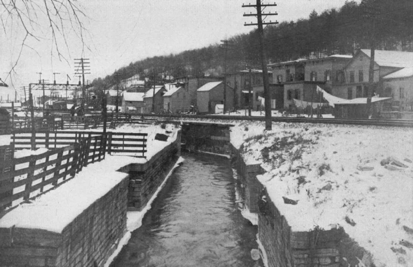
LOCK AT LITTLE FALLS, BUILT BY THE WESTERN INLAND LOCK NAVIGATION COMPANY ABOUT 1800.
View showing its present condition; the channel is now used as a head-race. In 1883 the Legislature transferred this lock, together with an adjacent stone bridge, to a commission for preservation as a historical relic.
"On the 3rd of October, 1797, a canal for the passage of boats from the Mohawk river to Wood creek was completed. The length of this canal is one mile and three quarters, and its width 47 ˝ feet -- and it may be used by boats drawing 3 ˝ feet water. It has two locks, one of 10, and the other of 8 feet lift, and a feeder.
"A few months after, a canal of a mile and one fourth long, 24 feet wide, and 4 deep, with 2 locks, was finished at the German Flatts; and the navigation of Wood creek has been since improved by locks and deep cuttings; and attempts have been made at different times to facilitate the Mohawk communication by dams, &c., which have been almost always unsuccessful.
"This company in their report to the legislature, of the 16th of February, 1798, disclaim all idea of a canal along the banks of the Mohawk, east of the Little Falls. Its only object appeared to be the improvements west of that place.
"On the 11th of April, 1808, the western company surrendered all its grant west of the Oneida lake. ...
"The causes of the total failure of the northern, and the partial failure of the western canal, are principally the following:
"1. The want of able American engineers. No genius can supply the absence of experience and instruction. ... General Schuyler was a man of great talents; but he was not a practical engineer. In the first stages of the undertaking, he superintended the whole operation, not only as president of both companies, but as civil engineer. The work was too mighty for his grasp.
"At a subsequent period, Mr. Weston, a celebrated English engineer, was employed; but he was totally ignorant of the country and the people. Hence between them both great mistakes were committed. Mr. Weston involved the company in great expense by an unnecessary deep cutting at Rome, which might easily have been avoided, by diverging a little through a swamp. The artificial bank of the canal at the Little Falls, was supported on the inside by a dry wall, which cost $15,000. This was found worse than useless; it served as a sieve to carry off the waters and to injure the bank, and it became necessary to remove it.
"The locks at Rome were originally made of brick, which not standing the frost, were replaced by stone: those at the Little Falls were built of wood, which soon rotting, stone was substituted -- and these seven locks probably put the company to an unnecessary expense of $70,000.
"There is a fine stone quarry a mile and a half from the Little Falls, of which the locks were made, after having been built of wood from ignorance of the vicinity of this stone. ...
"2. The high demand for damages, made by the proprietors of the lands through which the canal passed, and which were generally allowed. ...
"3. The modus operandi. Instead of operating through contractors, superintendents and labourers were employed, and paid by the day or the month. The consequence was, that the company was liable to be defrauded in every direction.
"4. The great defect was the want of funds -- and this naturally arose from the magnitude of the undertaking. It was too great for any individual or company, and it ought never to have gone out of the hands of the state." 41
As to the benefits conferred, Mr. Clinton says: "The water improvements to the north were abandoned, and those to the west were of little consequence. Two of the Portages only were surmounted, namely, at the Little Falls and at Rome -- That between Albany and Schenectady, and that at the Oswego Falls were never touched -- and the attempts to deepen the channels of the rivers, and to shorten the distances, were generally unavailing and fruitless. The expense of transportation continued the same by water as by land -- and no important facilities were created for the transportation of commodities." 42
"The inauspicious results of the attempts of the western company arrested for a long time the progress of internal navigation. An incorporated company had afterwards made canals and locks on the Seneca river west of Cayuga lake and an enterprising individual, of the name of Baldwin, had in one place made improvements below -- and this was the sum total of all such operations." 43
"The operations of the Western Inland Lock Navigation Company, however laudable for good intentions, were unfortunately calculated to dampen the zeal for internal navigation and to arrest its progress. The most popular and the strongest argument urged against the great system of Canal policy, was the failure of their attempts; and it may be truly said, that if that association had never had a being, the most serious obstacles which have been thrown in the way of our present measures would have never existed." 44
Of the same opinion was another early advocate of the Erie canal, who said: "It is a truth which ought not to be disguised, that the gross errors which were committed by the advocates of that scheme, in their estimates of the expense, and of the profits and advantages of those improvements, resulted in a complete failure of the benefits promised by its projectors.... Certain I am, that instead of facilitating, and encouraging subsequent canal operations, the history and experience of the Northern and Western Inland Lock Navigation Companies were powerful impediments to the enterprise of the Erie Canal." 45
An interesting bit of local history at Rome proves that the failure of the locks was not due to the poor quality of the bricks. These bricks, which were slightly larger than an ordinary building brick, after being removed from the locks, were used in constructing the first Court House in Rome, about 1806. This structure stood till 1848, when it was destroyed by fire. Then the bricks were used for a third time in a dwelling, which is still standing at the northeast corner of George and Court streets, in a state of good preservation. Probably the failure was due, as Mr. Watson said, to the poor quality of the mortar. Add to this deficiency the fact that the material was composed of small bricks rather than of large stones, and the failure is easily accounted for.
While the Western Inland Lock Navigation Company was endeavoring to open navigation to the central part of the state, the incorporation of another company was authorized for the purpose of completing communication with the Great Lakes. On April 5, 1798, was enacted the first law toward constructing a canal from Lake Erie to Lake Ontario. During the session of 1797, a similar bill had passed the Assembly, was amended by the Senate, but was laid aside in its amended form by the Assembly. This act of 1798 incorporated the Niagara Canal Company, and provided for a canal large enough for boats seventy feet long by sixteen feet wide and having a draught of four feet. The company was granted ten years in which to complete the canal. The contemplated route was seven miles long, having a descent of three hundred and twenty feet, and the estimated cost was half a million dollars for large boats, and double that sum for boats of seventy tons burden.
The law established a company for the purpose of opening a canal and lock navigation, to commence at Stedman's landing above the falls with a termination nearly opposite Queenstown. In 1796, surveys, levels and estimates were made by Benjamin Prescott, who was one of those interested in procuring the passage of the law. He estimated the expense of the project at $623,000 for a canal to accommodate large boats, and at $1,000,000 for sloops of seventy tons burden.
The organization of the company was perfected in 1799, with the election of James Watson as president, and Messrs. Prescott and E. Watson, two of the directors, were delegated as a committee to furnish the information that had been procured on the subject. A detailed report was made, "in which they (the directors) enlarged upon the great importance of the object in view, and presented various estimates of the expense of the canal, and of the tolls which would probably proceed from it if completed. But as the whole amount of tolls which were then expected to be received from the canal were estimated at only $14,000 per annum, and as the interest of the monies to be expended in the construction of the works would have exceeded $40,000 per annum, the committee advised that the immediate execution of the work ought not to be attempted, but expressed a decided conviction 'that in a few years the all important enterprise would be found both necessary and indispensable.' " 46 Subsequently Mr. La Trobe, a French engineer, was employed by the company to resurvey the route. He performed the work and presented new levels and estimates to the directors, and although the project excited much interest at the time, no other effort was made towards its consummation.
From a letter of Benjamin Wright may be learned the few subsequent operations by the Western Company. He says: --
"After Mr. Weston had completed the improvements at Rome, or Fort Stanwix, and a short cut and two locks at German Flatts, in Herkimer county, which was completed about the year 1798-99, he soon after returned to England, his native country.
"In 1802, the Western Inland Lock Navigation Company determined upon improving the navigation of Wood Creek from near Fort Stanwix to a small tributary stream six miles westerly, called Little Canada Creek. In this distance there was a descent of nearly twenty-four feet, and the navigation very indifferent and troublesome. The plan decided upon was by means of dams and locks, of which they constructed four in the distance above mentioned. George Huntington, Esq., of Rome, was their agent, and I was their engineer.
"After locating and determining all that was necessary for these works, the gentlemen composing the board of directors, of which General Schuyler was president, and Robert Bowne and Thomas Eddy two very prominent and active members, were so well satisfied with my manner of executing the duties of civil engineer, that they directed me to make a traverse and regular survey, ground plan, and profile of the Wood Creek, from the point at Little Canada Creek, before mentioned (where the improvements of 1802 ended) down to the Oneida Lake, where Wood Creek empties its waters. This I performed in the spring of 1803.
"Immediately on completing my work on Wood Creek, and returning the maps, plans, reports, &c. I received further directions from the president and directors to commence a survey of the Mohawk River from Fort Stanwix to Schenectady -- 'taking a regular traverse of the river, so as to show all its windings, its breadth, the descent in each rapid, and the descent between rapids, the depth of water in the channel at each rapid, and the depth in each pool between rapids at its lowest summer drought, the height of alluvial banks and all other remarks and observations which I might think useful.' -- 'And as a final duty, to strike out my own plan of improving the river in as cheap and economical a manner as possible, and one adapted to the situation and circumstances of the company.'
"This duty I performed in 1803, by recommending a compound of dams, locks, and short canals, so as to make a slack water navigation upon the cheapest possible and useful plan. Unfortunately the pecuniary affairs of the company never permitted them to carry any part of the proposed plan into effect.
"Things remained in their then state until the resolution of Judge Forman, in February, 1808, in the Assembly, he being at that time a member from Onondaga county, and myself a member from Oneida." 47
Many years were required to mature the next project. The work already done facilitated traffic to a limited extent, but the need of something better was felt, and the people were not then ready to commence the great undertaking which the situation demanded.
FOOTNOTES.
1. This report was entitled, A Memorial concerning the Furr-Trade of the Province of New York, Presented to his Excellency, William Burnet, Esq., Captain General and Governor, &c. by Cadwallader Colden, Surveyor General of the said Province, the 10th of November, 1724, and is found at length in Colden's History of the Five Indian Nations, printed in London in 1747. The map accompanying this history is reproduced in the present volume and shows how extensive and how accurate was the knowledge of the country at that early day.
2. Memorial concerning the Furr-Trade in Papers relating to an Act of the Assembly, etc., p. 28, printed in Colden's History of the Five Indian Nations. (London, 1747.)
3. Id. p. 30.
4. Memorial concerning the Furr-Trade, etc., p. 14.
5. Id. p. 34.
6. Memoir, etc., at the Celebration of the Completion of the New York Canals, by Cadwallader D. Colden, p. 11. (New York, 1825.)
7. Id. p. 12.
8. Id. p. 99.
9. Facts and Observations in Relation to the Origin and Completion of the Erie Canal, p. 3. (New York, 1825.)
10. Travels through the Interior Parts of North-America, in the Years 1766, 1767 and 1768. By J. Carver, p. 172. (London, 1778.)
11. Archer Butler Hulbert's Historic Highways of America. Vol. 14, pp. 18-19.
12. Proposals for the Speedy Settlement of the Waste and Unappropriated Lands on the Western Frontiers of the State of New York, and for the Improvement of the Inland Navigation between Albany and Oswego, p. 7. (New York, 1785.)
13. Journal of the Votes and Proceedings of the General Assembly of the Colony of New York, October 27, 1768, - January 1, 1769, p. 51. (New York, 1769, reprinted, Albany, 1820.)
14. P. 581.
15. The Life of George Washington, by John Marshall, Vol. II., p. 65. (Philadelphia, 1832.)
16. Assembly Journal, 1784, p. 41.
17. The Canal Policy of the State of New York, by Tacitus (generally ceded to have been De Witt Clinton), p. 12. (Albany, 1821.)
18. Watson's History ... of the Western Canals, p. 8.)
19. Id. p. 87.
20. Watson's History ... of the Western Canals, p. 88.
NOTE. -- In 1784 Washington had made an exploration through western territory. A summary of his Journal of this trip is quoted in Vol. 13 of Hulbert's Historic Highways of America, pp. 35-50, which gives in detail the notes of which Mr. Watson made a brief summary. This Journal has recently been made public for the first time in a publication by Mr. Hulbert, under the title of Washington and the West. The Potomac Company, to which Mr. Watson refers, began operations in 1785, and struggled with many difficulties for three years without accomplishing the opening of navigation. Then Washington was called to the Presidency of the United States, and the affairs of the company dragged along with no results till after the Erie canal was completed in 1825. Then the objects sought by the Potomac Company were undertaken by the Chesapeake and Ohio Canal Company.
21. Watson's History ... of the Western Canals, p. 11.
22. Id. p. 7.
23. Id. p. 12.
24. Assembly Journal, 1791, p. 4.
25. Assembly Journal, 1791, p. 84.
26. At that time Ł100 was equivalent to $250. The exact amount expended for the survey was $149.73.
27. Watson's History ... of the Western Canals, p. 42.
28. Id. p. 98.
29. Vindication of the claim of Elkanah Watson, Esq., to the Merit of Projecting the Lake Canal Policy, etc., by Robert Troup, p. 14. (Geneva, N.Y., 1821.)
30. Assembly Journal, 1792, p. 6.
31. Vindication of the Claim of Elkanah Watson, etc., appendix, p. 16.
32. Vindication of the Claim of Elkanah Watson, etc., appendix, pp. 33-35.
33. Id. p. 32.
34. Watson's History ... of the Western Canals, pp. 85-86. (The apparent discrepancy of subscribing twenty shares is probably explainable by the supposition that there were ten for each company.)
35. Id. p. 92.
36. Report of the Directors of the Western and Northern Inland Lock Navigation Companies, in the State of New York to the Legislature, pp. 3-4. (New York, 1796.)
37. Report of the Directors, etc., pp. 4-5.
38. Watson's History ... of the Western Canals, p. 92, et. seq.
39. Id. p. 98.
40. Id. p. 102.
41. The Canal Policy of the State of New York, by Tacitus (De Witt Clinton), pp. 16-17.
42. Id. p. vi.
43. Id. p. 19.
44. The Canal Policy of the State of New York, p. viii.
45. Letter of Judge Platt of Dr. Hosack in Memoir of De Witt Clinton, p. 380. (New York, 1829.)
46. Supplement to Troup's Letter to Brockholst Livingston ... on the Lake Canal Policy, pp. 5-6. (Albany, 1822.)
47. Letter to Dr. Hosack in Memoir of De Witt Clinton, pp. 501-502.
http://www.eriecanal.org/Texts/Whitford/1906/Chap01.html