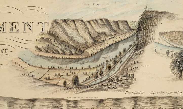
David Vaughan worked as a draftsman for the New York State Canal Department, drawing maps for the Erie Enlargement. Vaughan regularly embellished his work with perspective drawings of the views he encountered along the canal. This is one of several views of "The Noses" which Vaughan added to the perimeter of a large survey map he drew of the canal in the area near Canajoharie.
Frequent earthquakes in eastern New York State during the Taconic Orogeny (mountain building period) were caused by the Island Arc collision with Proto North America in the middle Ordovician, 460 million years ago, and resulted in long breaks in the rock, faults, which resemble those in California and Japan today. In some areas of the Mohawk Valley, rock blocks were either pushed up or dropped down. As the Mohawk River flowed east across the higher granite blocks to the lower ones, the river cut deep, narrow channels in the upper ones producing The Noses.
These formations created significant challenges for the canal builders. At the Noses, the canal had to be reduced from the normal 40 ft. width to10 ft. which significantly hindered the flow of traffic. At times, the towpath embankment even had to occupy part of the river bed.
The following is an excerpt from the Diary of Jonathan Pearson:
Grand Erie Canal Thursday July 25, 1833
"This morning when the sun was about an hour high, the cool shade of the evening had slowly
passed and the dew was sparkling in the beams of the rising sun, we came along a high ridge of
mountains betwixt which and us ran the noble Mohawk, fringed on either edge by overhanging
trees and the lowly underwood. The fertile banks for some distance are loaded with the yellow
grain and the waving grass which invite the sickle and scythe of the husbandman. The river and
canal run parallel with this ridge for some miles, until we come to Anthony's Nose where the
river has forced a way through the mountain barrier, forming an immense precipitous height on
the right so abruptly divided by the valley [and] the river that vegetation seems hardly able to
grow on his sides. This is called Anthony's Nose. In many places along this ridge and indeed
on the very nose are many passages down from the top to the bottom called slides, down which
logs are slid in the winter from the forest which clothes its top and sides. This is the only way in
which they can be brought to the bottom with any degree of practibility [sic]. It appears to me
that the Mohawk runs thro a pretty hilly country, for all the way on one side or the other and
generally on both are ranges of high hills which sometimes rise into lofty summits, the flatter
into meaner elevations, now widening so as to leave the valley broad and the river struggles to
gain his straitened [way?]. Especially is this the case at Anthony's Nose and several other places
thro which we have traveled today. These eminences are generally thickly covered with forests
of timber, except the lower ones, which admit of easy cultivation. This timber is cut and
transported down the river and canal to Troy and Albany where it brings a good price."
http://www.eriecanal.org/UnionCollege/timeline-add.html